
Topografische kaart Engeland
Interactieve kaart
Klik op de kaart om de hoogte weer te geven.
Over deze kaart
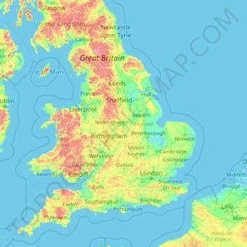
Naam: Topografische kaart Engeland, hoogte, reliëf.
Locatie: Engeland, Verenigd Koninkrijk (49.67400 -6.70475 55.91700 2.09191)
Gemiddelde hoogte: 55 m
Minimale hoogte: -3 m
Maximale hoogte: 966 m
Andere topografische kaarten
Klik op een kaart om zijn topografie, zijn hoogte en zijn reliëf te bekijken.
Loch Teth
Verenigd Koninkrijk > Schotland > Highland
Loch Teth, Highland, Schotland, Verenigd Koninkrijk
Gemiddelde hoogte: 94 m
Coll
Verenigd Koninkrijk > Schotland > Argyll and Bute > Arinagour
Coll, Arinagour, Argyll and Bute, Schotland, Verenigd Koninkrijk
Gemiddelde hoogte: 7 m
Ben Nevis
Verenigd Koninkrijk > Schotland > Highland
Ben Nevis, Highland, Schotland, Verenigd Koninkrijk
Gemiddelde hoogte: 912 m
Tobermory
Verenigd Koninkrijk > Schotland > Argyll and Bute
Tobermory, Argyll and Bute, Schotland, Verenigd Koninkrijk
Gemiddelde hoogte: 58 m
Lost
Verenigd Koninkrijk > Schotland > Aberdeenshire > Bellabeg
Lost, Bellabeg, Aberdeenshire, Schotland, AB36 8UQ, Verenigd Koninkrijk
Gemiddelde hoogte: 373 m
North Norfolk
Verenigd Koninkrijk > Engeland > Norfolk
North Norfolk, Norfolk, Engeland, Verenigd Koninkrijk
Gemiddelde hoogte: 26 m
Ilfracombe
Verenigd Koninkrijk > Engeland > Devon > North Devon
Ilfracombe, North Devon, Devon, Engeland, Verenigd Koninkrijk
Gemiddelde hoogte: 104 m
South Newbald
Verenigd Koninkrijk > Engeland > East Riding of Yorkshire
South Newbald, East Riding of Yorkshire, Engeland, YO43 4FF, Verenigd Koninkrijk
Gemiddelde hoogte: 68 m
Yorkshire
Verenigd Koninkrijk > Engeland
Yorkshire, Engeland, Verenigd Koninkrijk
Gemiddelde hoogte: 130 m
St Leonards
Verenigd Koninkrijk > Engeland > East Sussex
St Leonards, Hastings, East Sussex, Engeland, TN38 0NY, Verenigd Koninkrijk
Gemiddelde hoogte: 31 m
Little Heath
Verenigd Koninkrijk > Engeland > Hertfordshire > Dacorum > Potten End
Little Heath, Nettleden with Potten End, Potten End, Dacorum, Hertfordshire, Engeland, HP4 2RX, Verenigd Koninkrijk
Gemiddelde hoogte: 138 m
Whitewell
Verenigd Koninkrijk > Engeland > Lancashire > Ribble Valley
Whitewell, Bowland Forest Low, Ribble Valley, Lancashire, Engeland, BB7 3AT, Verenigd Koninkrijk
Gemiddelde hoogte: 184 m
Gorse Hill
Verenigd Koninkrijk > Engeland > Trafford
Gorse Hill, Trafford, Greater Manchester, Engeland, M32 0QG, Verenigd Koninkrijk
Gemiddelde hoogte: 28 m
Wroughton
Verenigd Koninkrijk > Engeland > Swindon > Wroughton
Wroughton, Swindon, Engeland, Verenigd Koninkrijk
Gemiddelde hoogte: 153 m
Nottinghamshire
Verenigd Koninkrijk > Engeland > Nottinghamshire
Nottinghamshire, Engeland, Verenigd Koninkrijk
Gemiddelde hoogte: 74 m
Fakenham
Verenigd Koninkrijk > Engeland > Norfolk > North Norfolk
Fakenham, North Norfolk, Norfolk, Engeland, Verenigd Koninkrijk
Gemiddelde hoogte: 46 m
Brighton
Verenigd Koninkrijk > Engeland > East Sussex
Brighton, East Sussex, Engeland, BN1 1HH, Verenigd Koninkrijk
Gemiddelde hoogte: 28 m
Old Ravenfield
Verenigd Koninkrijk > Engeland > Rotherham
Old Ravenfield, Rotherham, South Yorkshire, Engeland, S65 4NW, Verenigd Koninkrijk
Gemiddelde hoogte: 82 m
Londen
Verenigd Koninkrijk > Engeland > Londen
Londen, Groot-Londen, Engeland, SW1A 2DX, Verenigd Koninkrijk
Gemiddelde hoogte: 42 m
Ravensfield
Verenigd Koninkrijk > Engeland > Durham > Stanhope > Shittlehope
Ravensfield, Shittlehope, Stanhope, Durham, North East, Engeland, DL13 2YN, Verenigd Koninkrijk
Gemiddelde hoogte: 305 m
Wolverhampton
Verenigd Koninkrijk > Engeland
Wolverhampton, West Midlands Combined Authority, Engeland, Verenigd Koninkrijk
Gemiddelde hoogte: 138 m
Basingstoke
Verenigd Koninkrijk > Engeland > Hampshire > Basingstoke and Deane
Basingstoke, Basingstoke and Deane, Hampshire, Engeland, Verenigd Koninkrijk
Gemiddelde hoogte: 110 m
Lake District National Park
Verenigd Koninkrijk > Engeland
Lake District National Park, Engeland, Verenigd Koninkrijk
Gemiddelde hoogte: 206 m
Mansfield (Nottinghamshire)
Verenigd Koninkrijk > Engeland > Nottinghamshire
Mansfield (Nottinghamshire), Nottinghamshire, Engeland, Verenigd Koninkrijk
Gemiddelde hoogte: 117 m
Looe
Verenigd Koninkrijk > Engeland > Cornwall
Looe, Cornwall, Engeland, Verenigd Koninkrijk
Gemiddelde hoogte: 44 m
Glen Nevis
Verenigd Koninkrijk > Schotland > Highland
Glen Nevis, Highland, Schotland, PH33 6TE, Verenigd Koninkrijk
Gemiddelde hoogte: 178 m
Dumfries
Verenigd Koninkrijk > Schotland > Dumfries and Galloway
Dumfries, Dumfries and Galloway, Schotland, DG1 1HS, Verenigd Koninkrijk
Gemiddelde hoogte: 25 m
Salesbury
Verenigd Koninkrijk > Engeland > Lancashire > Ribble Valley
Salesbury, Ribble Valley, Lancashire, Engeland, Verenigd Koninkrijk
Gemiddelde hoogte: 77 m
Mallaig
Verenigd Koninkrijk > Schotland > Highland
Mallaig, Highland, Schotland, PH41 4QA, Verenigd Koninkrijk
Gemiddelde hoogte: 25 m
Gairloch
Verenigd Koninkrijk > Schotland > Highland
Gairloch, Highland, Schotland, IV21 2DU, Verenigd Koninkrijk
Gemiddelde hoogte: 77 m
Golspie
Verenigd Koninkrijk > Schotland > Highland
Golspie, Highland, Schotland, KW10 6TF, Verenigd Koninkrijk
Gemiddelde hoogte: 61 m
Wellingborough
Verenigd Koninkrijk > Engeland > North Northamptonshire
Wellingborough, North Northamptonshire, Engeland, NN8 1AF, Verenigd Koninkrijk
Gemiddelde hoogte: 76 m
Capel Curig
Verenigd Koninkrijk > Wales > Conwy
Capel Curig, Conwy, Wales, LL24 0EN, Verenigd Koninkrijk
Gemiddelde hoogte: 299 m
Uffington
Verenigd Koninkrijk > Engeland > Oxfordshire > Vale of White Horse
Uffington, Vale of White Horse, Oxfordshire, Engeland, Verenigd Koninkrijk
Gemiddelde hoogte: 138 m
Creigau Gleision
Verenigd Koninkrijk > Wales > Conwy
Creigau Gleision, Conwy, Wales, LL24 0EN, Verenigd Koninkrijk
Gemiddelde hoogte: 453 m
Heinis
Verenigd Koninkrijk > Schotland > Na h-Eileanan Siar
Heinis, Na h-Eileanan Siar, Schotland, HS8 5JN, Verenigd Koninkrijk
Gemiddelde hoogte: 14 m
Burton-on-Trent
Verenigd Koninkrijk > Engeland > Staffordshire > East Staffordshire
Burton-on-Trent, East Staffordshire, Staffordshire, Engeland, DE14 1JN, Verenigd Koninkrijk
Gemiddelde hoogte: 69 m
Glen Coe
Verenigd Koninkrijk > Schotland > Highland > Glencoe
Glen Coe, Glencoe, Highland, Schotland, Verenigd Koninkrijk
Gemiddelde hoogte: 414 m
River Clyde
Verenigd Koninkrijk > Schotland
River Clyde, Schotland, Verenigd Koninkrijk
Gemiddelde hoogte: 245 m
River
Verenigd Koninkrijk > Engeland > Kent > Dover
River, Dover, Kent, Engeland, Verenigd Koninkrijk
Gemiddelde hoogte: 80 m
River Ness
Verenigd Koninkrijk > Noord-Ierland > County Londonderry > Derry/Londonderry
River Ness, Derry/Londonderry, County Londonderry, Noord-Ierland, BT47 3EY, Verenigd Koninkrijk
Gemiddelde hoogte: 120 m
River Spey
Verenigd Koninkrijk > Schotland
River Spey, Schotland, Verenigd Koninkrijk
Gemiddelde hoogte: 336 m
West Northamptonshire
Verenigd Koninkrijk > Engeland
West Northamptonshire, Engeland, Verenigd Koninkrijk
Gemiddelde hoogte: 111 m
Kirkwall
Verenigd Koninkrijk > Schotland > Orkney Islands
Kirkwall, Orkney Islands, Schotland, KW15 1DH, Verenigd Koninkrijk
Gemiddelde hoogte: 27 m
Highgate
Verenigd Koninkrijk > Engeland > Birmingham
Highgate, Birmingham, West Midlands Combined Authority, Engeland, B12 0YT, Verenigd Koninkrijk
Gemiddelde hoogte: 126 m
Perth
Verenigd Koninkrijk > Schotland > Perth and Kinross
Perth, Perth and Kinross, Schotland, PH1 5SU, Verenigd Koninkrijk
Gemiddelde hoogte: 131 m
Potton
Verenigd Koninkrijk > Engeland > Central Bedfordshire
Potton, Central Bedfordshire, Engeland, Verenigd Koninkrijk
Gemiddelde hoogte: 51 m
Kilspindie
Verenigd Koninkrijk > Schotland > Perth and Kinross
Kilspindie, Perth and Kinross, Schotland, PH2 7RX, Verenigd Koninkrijk
Gemiddelde hoogte: 82 m
Aldbourne
Verenigd Koninkrijk > Engeland > Wiltshire
Aldbourne, Wiltshire, Engeland, Verenigd Koninkrijk
Gemiddelde hoogte: 195 m