
Topografische kaart Shillong
Interactieve kaart
Klik op de kaart om de hoogte weer te geven.
Over deze kaart
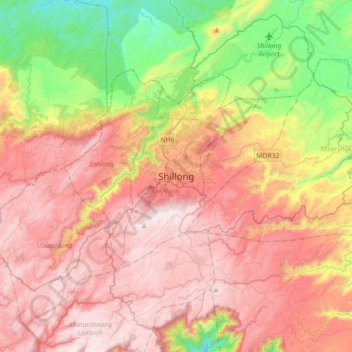
Naam: Topografische kaart Shillong, hoogte, reliëf.
Gemiddelde hoogte: 1.351 m
Minimale hoogte: 656 m
Maximale hoogte: 1.957 m
HQ Eastern Air Command (HQ, EAC) was shifted to Shillong on 10 Jun 63 from Kolkata and housed in the old buildings located at Nonglyer village at Upper Shillong, some 10 km from (Lower) Shillong, but at a greater altitude of around 6,000 feet AMSL. Initially a British military base, it was taken over by No. 58 Gorkha Regiment of the Indian Army post Independence in 1947. The Regiment was redeployed after the Sino-Indian War of 1962, making way for the IAF to step in. Only helicopters can operate from HQ, EAC, using a 12.7 hectare (31.3 acre) helipad.
Andere topografische kaarten
Klik op een kaart om zijn topografie, zijn hoogte en zijn reliëf te bekijken.
Sonapani Waterfall Cliff
India > Meghalaya > Mylliem > Shillong
Sonapani Waterfall Cliff, Lower Mawprem, Shillong, Mylliem, East Khasi Hills District, Meghalaya, 793001, India
Gemiddelde hoogte: 1.402 m