
Topografische kaart Southampton
Interactieve kaart
Klik op de kaart om de hoogte weer te geven.
Over deze kaart
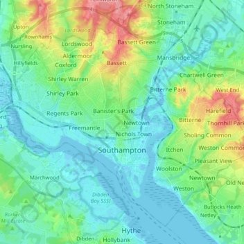
Naam: Topografische kaart Southampton, hoogte, reliëf.
Locatie: Southampton, South East, Engeland, VK (50.87151 -1.47901 50.95613 -1.32199)
Gemiddelde hoogte: 23 m
Minimale hoogte: -4 m
Maximale hoogte: 92 m
Andere topografische kaarten
Klik op een kaart om zijn topografie, zijn hoogte en zijn reliëf te bekijken.
Groot-Brittannië
VK > Engeland > Richmondshire
Groot-Brittannië, Richmondshire, North Yorkshire, Yorkshire and the Humber, Engeland, VK
Gemiddelde hoogte: 52 m
The Cotswolds AONB
The Cotswolds AONB, White Way, North Cerney, Cotswold, Gloucestershire, Zuidwest-Engeland, Engeland, GL7 7DF, VK
Gemiddelde hoogte: 107 m
Lancaster Canal
Lancaster Canal, Lancs, North West England, Engeland, PR2 3XZ, VK
Gemiddelde hoogte: 98 m
Peak District
VK > Engeland > Derbyshire Dales
Peak District, A623, Tideswell CP, Derbyshire Dales, Derbyshire, East Midlands, Engeland, SK17 8RN, VK
Gemiddelde hoogte: 225 m
North Yorkshire
North Yorkshire, Yorkshire and the Humber, Engeland, VK
Gemiddelde hoogte: 153 m
Bathampton
VK > Engeland > Bathampton
Bathampton, Bath and North East Somerset, Zuidwest-Engeland, Engeland, BA2 6, VK
Gemiddelde hoogte: 83 m
Walthamstow
VK > Engeland > Londen > Walthamstow
Walthamstow, Londen, Greater London, Engeland, E17 3AN, VK
Gemiddelde hoogte: 21 m
Leeds and Liverpool Canal
Leeds and Liverpool Canal, Lancs, North West England, Engeland, BD23 1QY, VK
Gemiddelde hoogte: 151 m
Merseyside
VK > Engeland > Wigan > Sefton
Merseyside, Chorley Road, Worthington, Wigan, Greater Manchester, North West England, Engeland, WN1 2XW, VK
Gemiddelde hoogte: 23 m
Old Haversham
VK > Engeland > Old Haversham
Old Haversham, Milton Keynes, South East, Engeland, MK19 7DZ, VK
Gemiddelde hoogte: 77 m
Welwyn Hatfield
VK > Engeland > Welwyn Hatfield
Welwyn Hatfield, Hertfordshire, East of England, Engeland, VK
Gemiddelde hoogte: 92 m
South Hams
VK > Engeland > South Hams
South Hams, Devon, Zuidwest-Engeland, Engeland, VK
Gemiddelde hoogte: 98 m
South Lakeland
VK > Engeland > South Lakeland
South Lakeland, Cumbria, North West England, Engeland, VK
Gemiddelde hoogte: 209 m
Chesterfield
VK > Engeland > Chesterfield
Chesterfield, Derbyshire, East Midlands, Engeland, VK
Gemiddelde hoogte: 127 m
Basingstoke and Deane
VK > Engeland > Basingstoke and Deane
Basingstoke and Deane, Hampshire, South East, Engeland, VK
Gemiddelde hoogte: 115 m
Wollaton
VK > Engeland > City of Nottingham > Wollaton
Wollaton, City of Nottingham, East Midlands, Engeland, NG8 2AF, VK
Gemiddelde hoogte: 58 m
Barrow-in-Furness
VK > Engeland > Barrow-in-Furness
Barrow-in-Furness, Cumbria, North West England, Engeland, VK
Gemiddelde hoogte: 22 m
Seaton Carew
VK > Engeland > Seaton Carew
Seaton Carew, Hartlepool, North East England, Engeland, TS25 1BT, VK
Gemiddelde hoogte: 4 m
Newnham
VK > Engeland > Basingstoke and Deane
Newnham, Basingstoke and Deane, Hampshire, South East, Engeland, VK
Gemiddelde hoogte: 82 m
West Kingsdown
West Kingsdown, Sevenoaks, Kent, South East, Engeland, VK
Gemiddelde hoogte: 154 m
Corpusty and Saxthorpe
VK > Engeland > North Norfolk
Corpusty and Saxthorpe, North Norfolk, Norfolk, East of England, Engeland, VK
Gemiddelde hoogte: 44 m
Bickenhill and Marston Green
Bickenhill and Marston Green, Solihull, West Midlands Combined Authority, West Midlands, Engeland, VK
Gemiddelde hoogte: 100 m
Forest of Dean
VK > Engeland > Forest of Dean
Forest of Dean, Gloucestershire, Zuidwest-Engeland, Engeland, VK
Gemiddelde hoogte: 86 m
Trent & Mersey Canal
Trent & Mersey Canal, Staffordshire, West Midlands, Engeland, ST15 8QW, VK
Gemiddelde hoogte: 140 m