
Topografische kaart Saquisilí
Interactieve kaart
Klik op de kaart om de hoogte weer te geven.
Over deze kaart
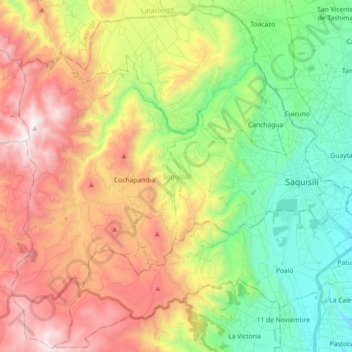
Naam: Topografische kaart Saquisilí, hoogte, reliëf.
Locatie: Saquisilí, Cotopaxi, 050408, Ecuador (-0.92426 -78.81640 -0.74788 -78.63489)
Gemiddelde hoogte: 3.434 m
Minimale hoogte: 2.814 m
Maximale hoogte: 4.282 m
Andere topografische kaarten
Klik op een kaart om zijn topografie, zijn hoogte en zijn reliëf te bekijken.
San Fransisco
Ecuador > Cotopaxi > Latacunga > Latacunga
San Fransisco, Eloy Alfaro, Latacunga, Cotopaxi, 050105, Ecuador
Gemiddelde hoogte: 2.887 m
Laguna Quilotoa
Ecuador > Cotopaxi > Sigchos > Chugchillan
Laguna Quilotoa, Chugchillan, Sigchos, Cotopaxi, Ecuador
Gemiddelde hoogte: 3.636 m
Volcán Cotopaxi
Ecuador > Cotopaxi > Latacunga > Mulaló
Volcán Cotopaxi, Mulaló, Latacunga, Cotopaxi, Ecuador
Gemiddelde hoogte: 5.021 m
La provincia
Ecuador > Cotopaxi > La provincia
La provincia, Isinlivi, Sigchos, Cotopaxi, Ecuador
Gemiddelde hoogte: 3.221 m
Chugchilan
Ecuador > Cotopaxi > Chugchilan
Chugchilan, Latacunga, Cotopaxi, 0504450, Ecuador
Gemiddelde hoogte: 2.909 m