
Topografische kaart The Quill
Interactieve kaart
Klik op de kaart om de hoogte weer te geven.
Over deze kaart
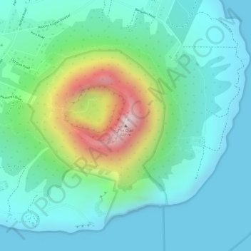
Naam: Topografische kaart The Quill, hoogte, reliëf.
Locatie: The Quill, Sint Eustatius, Caribisch Nederland, Nederland (17.47613 -62.95999 17.47623 -62.95989)
Gemiddelde hoogte: 143 m
Minimale hoogte: 0 m
Maximale hoogte: 559 m
Andere topografische kaarten
Klik op een kaart om zijn topografie, zijn hoogte en zijn reliëf te bekijken.
Sint Eustatius
Nederland > Caribisch Nederland
Sint Eustatius, Caribisch Nederland, Nederland
Gemiddelde hoogte: 48 m
Sint Eustatius
Nederland > Caribisch Nederland
Sint Eustatius, Caribisch Nederland, Nederland
Gemiddelde hoogte: 8 m
Washington-Slagbaai National Park
Nederland > Caribisch Nederland > Bonaire
Washington-Slagbaai National Park, Bonaire, Caribisch Nederland, Nederland
Gemiddelde hoogte: 45 m