Geolokaliseren

Topografische kaart St Albans

Interactieve kaart

Klik op de kaart om de hoogte weer te geven.

Over deze kaart

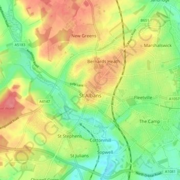
Naam: Topografische kaart St Albans, hoogte, reliëf.

Locatie: St Albans, Hertfordshire, England, United Kingdom (51.72913 -0.37529 51.78007 -0.29102)

Gemiddelde hoogte: 103 m

Minimale hoogte: 69 m

Maximale hoogte: 141 m

The borough consisted of the ancient parish of St Albans (also known as the Abbey parish) and parts of the parishes of St Michael and St Peter. The borough was reformed by the Municipal Corporations Act 1835 to become a municipal borough, and the boundary was adjusted to additionally include part of the parish of St Stephen. On 28 August 1877 the borough gained city status, following the elevation of St Albans Abbey to become a cathedral. The boundary was also adjusted in 1877 to include part of the parish of Sandridge.

Wikipedia (CC-BY-SA 3.0)

Andere topografische kaarten

Klik op een kaart om zijn topografie, zijn hoogte en zijn reliëf te bekijken.

Hitchin

United Kingdom > England > Hertfordshire > North Hertfordshire

Hitchin, North Hertfordshire, Hertfordshire, England, SG5 1BB, United Kingdom

Gemiddelde hoogte: 91 m

St Albans

United Kingdom > England > Hertfordshire > St Albans

St Albans, Hertfordshire, East of England, England, United Kingdom

Gemiddelde hoogte: 100 m

Watford

United Kingdom > England > Hertfordshire

Watford, Hertfordshire, England, United Kingdom

Gemiddelde hoogte: 77 m

Potters Bar

United Kingdom > England > Hertfordshire > Hertsmere

Potters Bar, Hertsmere, Hertfordshire, England, EN6 1QG, United Kingdom

Gemiddelde hoogte: 98 m

Hemel Hempstead

United Kingdom > England > Hertfordshire > Dacorum

Hemel Hempstead, Dacorum, Hertfordshire, England, HP1 1EW, United Kingdom

Gemiddelde hoogte: 130 m

Welwyn Garden City

United Kingdom > England > Hertfordshire > Welwyn Hatfield

Welwyn Garden City, Welwyn Hatfield, Hertfordshire, England, AL8 6TP, United Kingdom

Gemiddelde hoogte: 89 m

Puttenham

United Kingdom > England > Hertfordshire > Dacorum

Puttenham, Dacorum, Hertfordshire, England, HP23 4PR, United Kingdom

Gemiddelde hoogte: 89 m

South Mimms

United Kingdom > England > Hertfordshire > Hertsmere

South Mimms, Hertsmere, Hertfordshire, England, EN6 3PL, United Kingdom

Gemiddelde hoogte: 102 m

Connaught Park

United Kingdom > England > Hertfordshire > Hertsmere

Connaught Park, Hertsmere, Hertfordshire, England, WD23 2RA, United Kingdom

Gemiddelde hoogte: 82 m

Wigginton

United Kingdom > England > Hertfordshire > Dacorum > Wigginton

Wigginton, Dacorum, Hertfordshire, England, United Kingdom

Gemiddelde hoogte: 174 m

Bricket Wood

United Kingdom > England > Hertfordshire > St Albans

Bricket Wood, St Albans, Hertfordshire, England, AL2 3QS, United Kingdom

Gemiddelde hoogte: 82 m

Astonbury Wood

United Kingdom > England > Hertfordshire > East Hertfordshire > Aston

Astonbury Wood, Aston, East Hertfordshire, Hertfordshire, England, United Kingdom

Gemiddelde hoogte: 83 m

Old Dean

United Kingdom > England > Hertfordshire > Dacorum > Bovingdon

Old Dean, Bovingdon, Felden, Dacorum, Hertfordshire, England, United Kingdom

Gemiddelde hoogte: 144 m

Tudor Estate

United Kingdom > England > Hertfordshire > Watford

Tudor Estate, Watford, Hertfordshire, England, WD24 7NS, United Kingdom

Gemiddelde hoogte: 76 m

Stanstead St Margarets

United Kingdom > England > Hertfordshire > East Hertfordshire

Stanstead St Margarets, East Hertfordshire, Hertfordshire, England, SG12 8DH, United Kingdom

Gemiddelde hoogte: 48 m

Stevenage

United Kingdom > England > Hertfordshire

Stevenage, Hertfordshire, England, United Kingdom

Gemiddelde hoogte: 108 m

Burnham Green

United Kingdom > England > Hertfordshire > East Hertfordshire

Burnham Green, East Hertfordshire, Hertfordshire, England, AL6 0HA, United Kingdom

Gemiddelde hoogte: 102 m

Graveley

United Kingdom > England > Hertfordshire > North Hertfordshire

Graveley, North Hertfordshire, Hertfordshire, England, United Kingdom

Gemiddelde hoogte: 110 m

Furneux Pelham

United Kingdom > England > Hertfordshire > East Hertfordshire

Furneux Pelham, East Hertfordshire, Hertfordshire, England, United Kingdom

Gemiddelde hoogte: 113 m

Chapmore End

United Kingdom > England > Hertfordshire > East Hertfordshire > Tonwell

Chapmore End, Bengeo Rural, Tonwell, East Hertfordshire, Hertfordshire, England, SG12 0HF, United Kingdom

Gemiddelde hoogte: 65 m

Benington

United Kingdom > England > Hertfordshire > East Hertfordshire

Benington, East Hertfordshire, Hertfordshire, England, SG2 7LA, United Kingdom

Gemiddelde hoogte: 106 m

Little Heath

United Kingdom > England > Hertfordshire > Dacorum > Potten End

Little Heath, Nettleden with Potten End, Potten End, Dacorum, Hertfordshire, England, HP4 2RX, United Kingdom

Gemiddelde hoogte: 138 m

King's Meads

United Kingdom > England > Hertfordshire > East Hertfordshire > Ware

King's Meads, Glaxo Footbridge, Kings Hill, Ware, East Hertfordshire, Hertfordshire, England, SG12 0GG, United Kingdom

Gemiddelde hoogte: 53 m

Weston

United Kingdom > England > Hertfordshire > North Hertfordshire

Weston, North Hertfordshire, Hertfordshire, England, United Kingdom

Gemiddelde hoogte: 126 m

St Ippolyts

United Kingdom > England > Hertfordshire > North Hertfordshire

St Ippolyts, North Hertfordshire, Hertfordshire, England, United Kingdom

Gemiddelde hoogte: 103 m

Broken Green

United Kingdom > England > Hertfordshire > East Hertfordshire

Broken Green, Standon, East Hertfordshire, Hertfordshire, England, SG11 1NH, United Kingdom

Gemiddelde hoogte: 97 m

Highfield Park

United Kingdom > England > Hertfordshire > St Albans > Colney Heath

Highfield Park, Colney Heath, St Albans, Hertfordshire, England, United Kingdom

Gemiddelde hoogte: 87 m

Borehamwood

United Kingdom > England > Hertfordshire > Hertsmere

Borehamwood, Hertsmere, Hertfordshire, England, WD6 5HL, United Kingdom

Gemiddelde hoogte: 104 m

Moorend

United Kingdom > England > Hertfordshire > Dacorum > Corner Hall

Moorend, Corner Hall, Dacorum, Hertfordshire, England, HP1 1JP, United Kingdom

Gemiddelde hoogte: 121 m

Norton

United Kingdom > England > Hertfordshire > Letchworth

Norton, Letchworth, Hertfordshire, England, SG6 1AG, United Kingdom

Gemiddelde hoogte: 75 m

Letchworth

United Kingdom > England > Hertfordshire > North Hertfordshire > Letchworth

Letchworth, North Hertfordshire, Hertfordshire, East of England, England, SG6 3BF, United Kingdom

Gemiddelde hoogte: 80 m

Little Amwell

United Kingdom > England > Hertfordshire > East Hertfordshire

Little Amwell, East Hertfordshire, Hertfordshire, England, SG13 7QX, United Kingdom

Gemiddelde hoogte: 65 m

Moxon Avenue Open Space

United Kingdom > England > Hertfordshire > Cheshunt

Moxon Avenue Open Space, Cheshunt, Broxbourne, Hertfordshire, England, United Kingdom

Gemiddelde hoogte: 25 m

Hinxworth

United Kingdom > England > Hertfordshire > North Hertfordshire

Hinxworth, North Hertfordshire, Hertfordshire, England, United Kingdom

Gemiddelde hoogte: 48 m

Amwell

United Kingdom > England > Hertfordshire > St Albans > Wheathampstead

Amwell, Wheathampstead, St Albans, Hertfordshire, England, AL4 8EB, United Kingdom

Gemiddelde hoogte: 106 m

Great Ashby

United Kingdom > England > Hertfordshire > North Hertfordshire

Great Ashby, North Hertfordshire, Hertfordshire, England, United Kingdom

Gemiddelde hoogte: 134 m

Spellbrook

United Kingdom > England > Hertfordshire > East Hertfordshire > Sawbridgeworth

Spellbrook, Sawbridgeworth, East Hertfordshire, Hertfordshire, England, CM23 4RE, United Kingdom

Gemiddelde hoogte: 71 m

Westmill

United Kingdom > England > Hertfordshire > East Hertfordshire

Westmill, East Hertfordshire, Hertfordshire, England, United Kingdom

Gemiddelde hoogte: 108 m

Hertingfordbury

United Kingdom > England > Hertfordshire > East Hertfordshire

Hertingfordbury, East Hertfordshire, Hertfordshire, England, SG14 2LD, United Kingdom

Gemiddelde hoogte: 61 m

Whitwell

United Kingdom > England > Hertfordshire > North Hertfordshire

Whitwell, North Hertfordshire, Hertfordshire, England, SG4 8AN, United Kingdom

Gemiddelde hoogte: 122 m

Knebworth Country Park

United Kingdom > England > Hertfordshire > North Hertfordshire > Knebworth

Knebworth Country Park, Knebworth, Old Knebworth, North Hertfordshire, Hertfordshire, England, United Kingdom

Gemiddelde hoogte: 116 m

Aston

United Kingdom > England > Hertfordshire > East Hertfordshire

Aston, East Hertfordshire, Hertfordshire, England, United Kingdom

Gemiddelde hoogte: 99 m

Bishop's Stortford

United Kingdom > England > Hertfordshire > East Hertfordshire

Bishop's Stortford, East Hertfordshire, Hertfordshire, England, United Kingdom

Gemiddelde hoogte: 83 m

Northchurch

United Kingdom > England > Hertfordshire > Dacorum > Northchurch

Northchurch, Dacorum, Hertfordshire, England, United Kingdom

Gemiddelde hoogte: 162 m

Ayot St Peter

United Kingdom > England > Hertfordshire > Welwyn Hatfield > Welwyn Garden City

Ayot St Peter, Welwyn Garden City, Welwyn Hatfield, Hertfordshire, England, United Kingdom

Gemiddelde hoogte: 103 m

Tringford Reservoir

United Kingdom > England > Hertfordshire > Dacorum > Tring > Wilstone

Tringford Reservoir, Tring, Wilstone, Dacorum, Hertfordshire, England, United Kingdom

Gemiddelde hoogte: 119 m

Gobions Pond

United Kingdom > England > Hertfordshire > Welwyn Hatfield > Brookmans Park > Swanley Bar

Gobions Pond, Swanley Bar, North Mymms, Brookmans Park, Welwyn Hatfield, Hertfordshire, England, United Kingdom

Gemiddelde hoogte: 106 m

Hatfield

United Kingdom > England > Hertfordshire > Welwyn Hatfield

Hatfield, Welwyn Hatfield, Hertfordshire, England, United Kingdom

Gemiddelde hoogte: 90 m

Blackmore End

United Kingdom > England > Hertfordshire > St Albans > Wheathampstead

Blackmore End, Wheathampstead, St Albans, Hertfordshire, England, AL4 8LX, United Kingdom

Gemiddelde hoogte: 114 m

Wymondley

United Kingdom > England > Hertfordshire > North Hertfordshire > Little Wymondley

Wymondley, Little Wymondley, North Hertfordshire, Hertfordshire, England, United Kingdom

Gemiddelde hoogte: 96 m