
Topografische kaart Chichagof Island
Interactieve kaart
Klik op de kaart om de hoogte weer te geven.
Over deze kaart
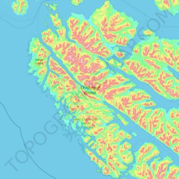
Naam: Topografische kaart Chichagof Island, hoogte, reliëf.
Locatie: Chichagof Island, Sitka, Alaska, VS (57.36791 -136.44771 58.28798 -134.82777)
Gemiddelde hoogte: 162 m
Minimale hoogte: -7 m
Maximale hoogte: 1.131 m
Andere topografische kaarten
Klik op een kaart om zijn topografie, zijn hoogte en zijn reliëf te bekijken.
Kobuk Valley National Park
Kobuk Valley National Park, Northwest Arctic, Alaska, VS
Gemiddelde hoogte: 331 m
Gates of the Arctic
Gates of the Arctic, Unorganized Borough, Alaska, VS
Gemiddelde hoogte: 663 m
Glacier Bay National Park
Glacier Bay National Park, Hoonah-Angoon, Alaska, VS
Gemiddelde hoogte: 556 m