
Topografische kaart Albenga
Interactieve kaart
Klik op de kaart om de hoogte weer te geven.
Over deze kaart
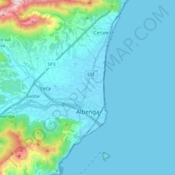
Naam: Topografische kaart Albenga, hoogte, reliëf.
Locatie: Albenga, Savona, Ligurië, Italië (44.02287 8.09942 44.10121 8.22985)
Gemiddelde hoogte: 85 m
Minimale hoogte: -1 m
Maximale hoogte: 761 m
Andere topografische kaarten
Klik op een kaart om zijn topografie, zijn hoogte en zijn reliëf te bekijken.