Geolokaliseren

Topografische kaart Amarillo

Interactieve kaart

Klik op de kaart om de hoogte weer te geven.

Over deze kaart

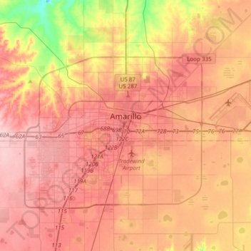
Naam: Topografische kaart Amarillo, hoogte, reliëf.

Locatie: Amarillo, Potter County, Texas, United States (35.10200 -101.95624 35.29448 -101.65378)

Gemiddelde hoogte: 1.097 m

Minimale hoogte: 999 m

Maximale hoogte: 1.154 m

Extreme temperatures range from −16 °F (−26.7 °C) on February 12, 1899 to 111 °F (43.9 °C) on June 26, 2011, but lows do not typically dip to 0 °F or −17.8 °C in most years, while highs above 100 °F or 37.8 °C are seen on 4.7 days on average. On average, there are 5.9 days of lows at or below 10 °F or −12.2 °C, 8.8 days where the temperature fails to rise above freezing, and 61 days of 90 °F (32.2 °C)+ highs. Unlike in the Rio Grande Valley or eastern portions of Texas, days where the low does not fall below 70 °F or 21.1 °C are relatively rare, due to the aridity and elevation. Blizzards occur occasionally, but snowfall is typically light, averaging nearly 18 inches or 46 centimetres seasonally and the median figure is near 10 inches or 25 centimetres. Amarillo is also recorded as the windiest city in the U.S. by the Weather Channel.

Wikipedia (CC-BY-SA 3.0)

Andere topografische kaarten

Klik op een kaart om zijn topografie, zijn hoogte en zijn reliëf te bekijken.

Amarillo

United States > Texas > Potter County

Amarillo, Potter County, Texas, United States

Gemiddelde hoogte: 1.097 m

Alibates Flint Quarries National Monument

United States > Texas > Potter County

Alibates Flint Quarries National Monument, Potter County, Texas, 79036, United States

Gemiddelde hoogte: 947 m

Bushland

United States > Texas > Potter County

Bushland, Potter County, Texas, 79012, United States

Gemiddelde hoogte: 1.166 m

Amarillo

United States > Texas > Potter County > Amarillo

Amarillo, Potter County, Texas, 79105, United States

Gemiddelde hoogte: 1.090 m