
Topografische kaart Vitoria-Gasteiz
Interactieve kaart
Klik op de kaart om de hoogte weer te geven.
Over deze kaart
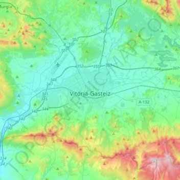
Naam: Topografische kaart Vitoria-Gasteiz, hoogte, reliëf.
Gemiddelde hoogte: 626 m
Minimale hoogte: 475 m
Maximale hoogte: 1.167 m
Andere topografische kaarten
Klik op een kaart om zijn topografie, zijn hoogte en zijn reliëf te bekijken.
Ali/Ehari
Spanje > Autonome Gemeenschap Baskenland > Gasteizko kuadrilla/Cuadrilla de Vitoria > Vitoria-Gasteiz
Gemiddelde hoogte: 520 m