Geolokaliseren

Topografische kaart Queens

Interactieve kaart

Klik op de kaart om de hoogte weer te geven.

Over deze kaart

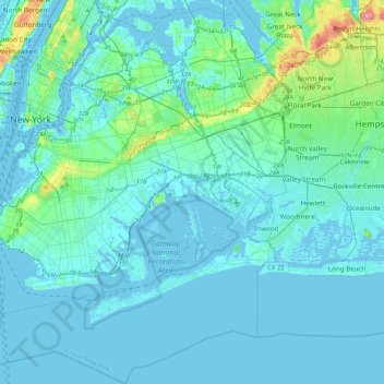
Naam: Topografische kaart Queens, hoogte, reliëf.

Locatie: Queens, Queens County, NYC, New York, VS (40.54233 -73.96269 40.80092 -73.70018)

Gemiddelde hoogte: 12 m

Minimale hoogte: -8 m

Maximale hoogte: 110 m

Andere topografische kaarten

Klik op een kaart om zijn topografie, zijn hoogte en zijn reliëf te bekijken.

Manhattan

VS > New York > NYC

Chinatown, Manhattan Community Board 3, Manhattan, New York County, NYC, New York, VS

Gemiddelde hoogte: 12 m

BK

VS > New York > NYC

BK, Kings County, NYC, New York, VS

Gemiddelde hoogte: 10 m

Todt Hill

VS > New York > NYC

Todt Hill, Staten Island, Richmond County, NYC, New York, 10304, VS

Gemiddelde hoogte: 75 m

Harlem

VS > New York > NYC

Harlem, Manhattan, Manhattan Community Board 10, New York County, NYC, New York, VS

Gemiddelde hoogte: 16 m

Kings County

VS > New York > NYC

Kings County, NYC, New York, VS

Gemiddelde hoogte: 9 m