Geolokaliseren

Topografische kaart Dallas

Interactieve kaart

Klik op de kaart om de hoogte weer te geven.

Over deze kaart

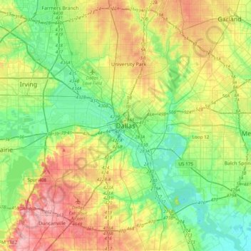
Naam: Topografische kaart Dallas, hoogte, reliëf.

Locatie: Dallas, Dallas County, Texas, 75242, United States (32.61627 -96.95686 32.93627 -96.63686)

Gemiddelde hoogte: 158 m

Minimale hoogte: 110 m

Maximale hoogte: 238 m

Dallas and its surrounding area are mostly flat. The city lies at elevations ranging from 450 to 550 feet (137 to 168 m) above sea level. The western edge of the Austin Chalk Formation, a limestone escarpment (also known as the "White Rock Escarpment"), rises 230 feet (70 m) and runs roughly north–south through Dallas County. South of the Trinity River, the uplift is particularly noticeable in the neighborhoods of Oak Cliff and the adjacent cities of Cockrell Hill, Cedar Hill, Grand Prairie, and Irving. Marked variations in terrain are also found in cities immediately to the west in Tarrant County surrounding Fort Worth, as well as along Turtle Creek north of Downtown.

Andere topografische kaarten

Klik op een kaart om zijn topografie, zijn hoogte en zijn reliëf te bekijken.

Klyde Warren Park-Arts District PID

United States > Texas > Dallas County > Dallas

Klyde Warren Park-Arts District PID, Dallas, Dallas County, Texas, 75201, United States

Gemiddelde hoogte: 143 m

Klyde Warren Park

United States > Texas > Dallas County > Dallas

Klyde Warren Park, Klyde Warren Park-Arts District PID, Dallas, Dallas County, Texas, 75201, United States

Gemiddelde hoogte: 142 m

Pioneer Park

United States > Texas > Dallas County > Dallas

Pioneer Park, Downtown PID, Dallas, Dallas County, Texas, United States

Gemiddelde hoogte: 135 m