
Topografische kaart Col du Lautaret
Interactieve kaart
Klik op de kaart om de hoogte weer te geven.
Col du Lautaret
Op de Col du Lautaret, op een hoogte van 2,100 meter, is de Jardin botanique alpin gevestigd. Deze plantentuin, ook Jardin d'altitude des cinq continents genaamd, maakt onderdeel uit van het Station alpine Joseph Fourier. In deze tuin worden planten uit de Alpen, de Kaukasus, de Andes, de Himalaya en de poolstreken gekweekt.
Over deze kaart
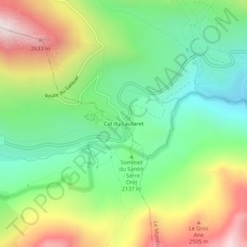
Naam: Topografische kaart Col du Lautaret, hoogte, reliëf.
Gemiddelde hoogte: 2.261 m
Minimale hoogte: 1.804 m
Maximale hoogte: 3.117 m