
Topografische kaart Hourtin
Interactieve kaart
Klik op de kaart om de hoogte weer te geven.
Over deze kaart
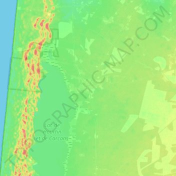
Naam: Topografische kaart Hourtin, hoogte, reliëf.
Gemiddelde hoogte: 19 m
Minimale hoogte: 0 m
Maximale hoogte: 63 m
Andere topografische kaarten
Klik op een kaart om zijn topografie, zijn hoogte en zijn reliëf te bekijken.
Les Chapelains
Frankrijk > Nieuw-Aquitanië > Gironde > Saint-André-et-Appelles > Saint-André
Gemiddelde hoogte: 80 m