
Topografische kaart Aconcagua
Interactieve kaart
Klik op de kaart om de hoogte weer te geven.
Aconcagua
Voor bergbeklimmers is de Aconcagua een gemakkelijke berg om te beklimmen, wanneer hij vanuit het noorden wordt benaderd via de normale route. Op deze route is geen echt klimmen nodig, maar de effecten van de grote hoogte zijn zwaar. De luchtdruk is op de top 40% van het zeeniveau. Het record voor de normale, noordelijke route is 5 uur en 45 minuten, behaald in 1991. De routes naar de piek via de zuidelijke en zuidwestelijke bergkammen zijn zwaarder en de zuidelijke klim wordt als zeer zwaar beschouwd.
Over deze kaart
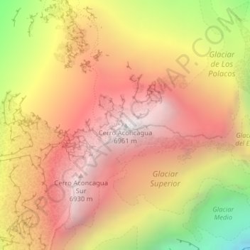
Naam: Topografische kaart Aconcagua, hoogte, reliëf.
Gemiddelde hoogte: 6.201 m
Minimale hoogte: 5.031 m
Maximale hoogte: 6.947 m