Geolokaliseren

Topografische kaart Spokane

Interactieve kaart

Klik op de kaart om de hoogte weer te geven.

Over deze kaart

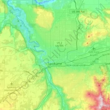
Naam: Topografische kaart Spokane, hoogte, reliëf.

Locatie: Spokane, Spokane County, Washington, United States (47.58678 -117.60400 47.75880 -117.30386)

Gemiddelde hoogte: 655 m

Minimale hoogte: 470 m

Maximale hoogte: 1.116 m

Spokane is located on the Spokane River in eastern Washington at an elevation of 1,843 feet (562 m) above sea level, about 18 miles (29 km) from Idaho, 92 miles (148 km) south of the Canadian border, 229 miles (369 km) due east of Seattle, and 279 miles (449 km) southwest of Calgary. The lowest elevation in the city of Spokane is the northernmost point of the Spokane River within city limits (in Riverside State Park) at 1,608 feet (490 m); the highest elevation is on the northeast side, near the community of Hillyard (though closer to Beacon Hill and the North Hill Reservoir) at 2,591 feet (790 m). Spokane is part of the Inland Northwest region, consisting of eastern Washington, north Idaho, northwestern Montana, and northeastern Oregon. The city has a total area of 60.02 square miles (155.45 km2), of which 59.25 square miles (153.46 km2) is land and 0.77 square miles (1.99 km2) is water.

Wikipedia (CC-BY-SA 3.0)

Andere topografische kaarten

Klik op een kaart om zijn topografie, zijn hoogte en zijn reliëf te bekijken.

Spokane Valley

United States > Washington > Spokane County

Spokane Valley, Spokane County, Washington, United States

Gemiddelde hoogte: 673 m

Hampton Bay

United States > Washington > Spokane County

Hampton Bay, Spokane County, Washington, United States

Gemiddelde hoogte: 666 m

Nine Mile Falls

United States > Washington > Spokane County

Nine Mile Falls, Spokane County, Washington, 99026, United States

Gemiddelde hoogte: 536 m

Mica Peak

United States > Washington > Spokane County

Mica Peak, Spokane County, Washington, United States

Gemiddelde hoogte: 1.311 m

Otis Orchards-East Farms

United States > Washington > Spokane County

Otis Orchards-East Farms, Spokane County, Washington, United States

Gemiddelde hoogte: 668 m

Mount Spokane State Park

United States > Washington > Spokane County

Mount Spokane State Park, Spokane County, Washington, United States

Gemiddelde hoogte: 976 m

Country Homes

United States > Washington > Spokane County

Country Homes, Spokane County, Washington, 99251, United States

Gemiddelde hoogte: 599 m

Mead

United States > Washington > Spokane County

Mead, Spokane County, Washington, 99021, United States

Gemiddelde hoogte: 585 m

Mica

United States > Washington > Spokane County

Mica, Spokane County, Washington, 99023, United States

Gemiddelde hoogte: 772 m

East Spokane

United States > Washington > Spokane County > Spokane Valley > East Spokane

East Spokane, Spokane Valley, Spokane County, Washington, 99260, United States

Gemiddelde hoogte: 625 m

Riverfront Park

United States > Washington > Spokane County > Spokane

Riverfront Park, Spokane, Spokane County, Washington, United States

Gemiddelde hoogte: 583 m

Beacon Hill

United States > Washington > Spokane County

Beacon Hill, Spokane County, Washington, 99211, United States

Gemiddelde hoogte: 659 m

Orchard Prairie

United States > Washington > Spokane County

Orchard Prairie, Spokane County, Washington, United States

Gemiddelde hoogte: 682 m