
Topografische kaart Kohima
Interactieve kaart
Klik op de kaart om de hoogte weer te geven.
Over deze kaart
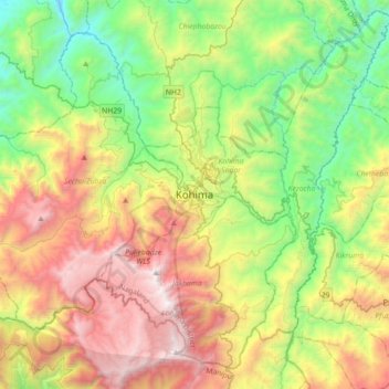
Naam: Topografische kaart Kohima, hoogte, reliëf.
Locatie: Kohima, Kohima Sadar, Kohima, Nagaland, 797001, India (25.50188 93.94192 25.82188 94.26192)
Gemiddelde hoogte: 1.425 m
Minimale hoogte: 430 m
Maximale hoogte: 2.993 m
Kohima district is the land of the Angami Naga and Rengma Naga tribe. It is situated in the foothills of Japfu range located south of Kohima District (25°40′N 94°07′E / 25.67°N 94.12°E / 25.67; 94.12) and has an average elevation of 1,261 metres (4137 feet).