
Topografische kaart Kernville
Interactieve kaart
Klik op de kaart om de hoogte weer te geven.
Over deze kaart
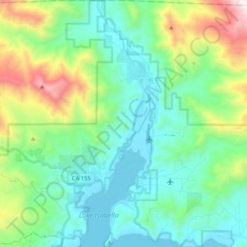
Naam: Topografische kaart Kernville, hoogte, reliëf.
Locatie: Kernville, Kern County, California, 93238, United States (35.67364 -118.46604 35.79250 -118.40277)
Gemiddelde hoogte: 1.135 m
Minimale hoogte: 779 m
Maximale hoogte: 2.244 m
Kernville is a census-designated place (CDP) in the southern Sierra Nevada, in Kern County, California, United States. Kernville is located 42 miles (68 km) northeast of Bakersfield, at an elevation of 2,667 feet (813 m). The population was 1,549 at the 2020 United States census, up from 1,395 at the 2010 census, but below the 2000 census total of 1,736.
Andere topografische kaarten
Klik op een kaart om zijn topografie, zijn hoogte en zijn reliëf te bekijken.
Tehachapi
United States > California > Kern County
Tehachapi, Kern County, California, 93561, United States
Gemiddelde hoogte: 1.414 m
Mojave
United States > California > Kern County
Mojave, Kern County, California, United States
Gemiddelde hoogte: 857 m
Wasco
United States > California > Kern County
Wasco, Kern County, California, United States
Gemiddelde hoogte: 101 m
Cantil
United States > California > Kern County
Cantil, Kern County, California, United States
Gemiddelde hoogte: 628 m
Woodford
United States > California > Kern County
Woodford, El Rita, Kern County, California, 93531, United States
Gemiddelde hoogte: 899 m
City of Shafter
United States > California > Kern County
City of Shafter, Kern County, California, United States
Gemiddelde hoogte: 118 m
Tehachapi Mountain
United States > California > Kern County
Tehachapi Mountain, Kern County, California, United States
Gemiddelde hoogte: 2.142 m
Rosamond
United States > California > Kern County
Rosamond, Kern County, California, 93560, United States
Gemiddelde hoogte: 749 m
Baker
United States > California > Kern County > Boron
Baker, Boron, Kern County, California, United States
Gemiddelde hoogte: 765 m
Gulf
United States > California > Kern County
Gulf, Kern County, CAL Fire Contract Counties, California, United States
Gemiddelde hoogte: 88 m
Kern City
United States > California > Kern County > Bakersfield
Kern City, Bakersfield, Kern County, CAL Fire Southern Region, California, 93309, United States
Gemiddelde hoogte: 119 m
Golden Hills
United States > California > Kern County > Golden Hills
Golden Hills, Kern County, California, United States
Gemiddelde hoogte: 1.275 m
Onyx
United States > California > Kern County
Onyx, Kern County, California, 93255, United States
Gemiddelde hoogte: 1.205 m
Arvin
United States > California > Kern County
Arvin, Kern County, California, United States
Gemiddelde hoogte: 130 m
California City
United States > California > Kern County
California City, Kern County, California, United States
Gemiddelde hoogte: 845 m
Buttonwillow
United States > California > Kern County > Buttonwillow
Buttonwillow, Kern County, California, 93206, United States
Gemiddelde hoogte: 87 m
Rosedale
United States > California > Kern County
Rosedale, Kern County, CAL Fire Southern Region, California, United States
Gemiddelde hoogte: 107 m
Frazier Park
United States > California > Kern County
Frazier Park, Kern County, California, United States
Gemiddelde hoogte: 1.533 m
Oil City
United States > California > Kern County
Oil City, Kern River Oil Field, Kern County, California, 93305, United States
Gemiddelde hoogte: 162 m
Walong
United States > California > Kern County > Keene
Walong, Keene, Kern County, California, United States
Gemiddelde hoogte: 998 m
McKittrick
United States > California > Kern County
McKittrick, Kern County, California, 93251, United States
Gemiddelde hoogte: 388 m
Taft
United States > California > Kern County > Taft > Taft
Taft, Kern County, California, 93268, United States
Gemiddelde hoogte: 301 m
China Lake
United States > California > Kern County > Ridgecrest > China Lake
China Lake, Ridgecrest, Kern County, California, 93555-2508, United States
Gemiddelde hoogte: 689 m
Goler Heights
United States > California > Kern County > Goler Heights
Goler Heights, Kern County, California, United States
Gemiddelde hoogte: 822 m
Edison
United States > California > Kern County
Edison, Kern County, California, 93303, United States
Gemiddelde hoogte: 178 m
Taft
United States > California > Kern County
Taft, Kern County, California, 93268, United States
Gemiddelde hoogte: 370 m
Pine Mountain Club
United States > California > Kern County
Pine Mountain Club, Kern County, California, 93222, United States
Gemiddelde hoogte: 1.867 m
Rowen
United States > California > Kern County
Rowen, Kern County, California, 93531, United States
Gemiddelde hoogte: 806 m
Bakersfield
United States > California > Kern County
Bakersfield, Kern County, California, United States
Gemiddelde hoogte: 157 m
Edwards Air Force Base
United States > California > Kern County
Edwards Air Force Base, Kern County, California, United States
Gemiddelde hoogte: 730 m
Lebec
United States > California > Kern County
Lebec, Kern County, California, 93243, United States
Gemiddelde hoogte: 1.162 m
Rosedale
United States > California > Kern County
Rosedale, Kern County, California, United States
Gemiddelde hoogte: 113 m
Inyokern
United States > California > Kern County > Inyokern
Inyokern, Kern County, California, United States
Gemiddelde hoogte: 753 m