
Topografische kaart Palestine
Interactieve kaart
Klik op de kaart om de hoogte weer te geven.
Over deze kaart
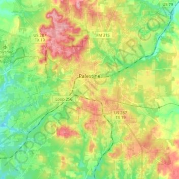
Naam: Topografische kaart Palestine, hoogte, reliëf.
Locatie: Palestine, Anderson County, Texas, United States (31.69527 -95.72426 31.80843 -95.56776)
Gemiddelde hoogte: 136 m
Minimale hoogte: 85 m
Maximale hoogte: 204 m
About 40% of the content from the 2003 Space Shuttle Columbia disaster was recovered. seven astronauts were killed in the accident.[19] Debris from Columbia was found in and outside Palestine and other East Texas towns.[20][21] Palestine's NASA Columbia Scientific Balloon Facility (renamed in honor of the shuttle crew), has flown 1,700 high-altitude balloons for universities and research agencies.
Andere topografische kaarten
Klik op een kaart om zijn topografie, zijn hoogte en zijn reliëf te bekijken.
Daly Mountain
United States > Texas > Anderson County > Neches
Daly Mountain, Neches, Anderson County, Texas, 75779, United States
Gemiddelde hoogte: 128 m
Fosterville
United States > Texas > Anderson County
Fosterville, Anderson County, Texas, United States
Gemiddelde hoogte: 133 m
Yard
United States > Texas > Anderson County
Yard, Anderson County, Texas, United States
Gemiddelde hoogte: 78 m