
Topografische kaart Saint John
Interactieve kaart
Klik op de kaart om de hoogte weer te geven.
Over deze kaart
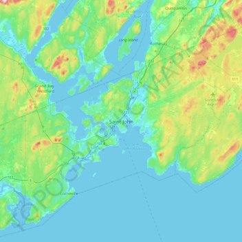
Naam: Topografische kaart Saint John, hoogte, reliëf.
Gemiddelde hoogte: 44 m
Minimale hoogte: -8 m
Maximale hoogte: 241 m
The topography surrounding Saint John is hilly; a result of the influence of two coastal mountain ranges which run along the Bay of Fundy – the St. Croix Highlands and the Caledonia Highlands. The soil throughout the region is extremely rocky with frequent granite outcrops. The coastal plain hosts numerous freshwater lakes in the eastern, western and northern parts of the city.
Andere topografische kaarten
Klik op een kaart om zijn topografie, zijn hoogte en zijn reliëf te bekijken.
Saint John
Canada > New Brunswick > Saint John
Saint John, Saint John County, New Brunswick, Canada
Gemiddelde hoogte: 39 m
Reversing Falls
Canada > New Brunswick > Saint John
Reversing Falls, City of Saint John, Saint John County, New Brunswick, E2M 3N4, Canada
Gemiddelde hoogte: 20 m
Saint John Harbour
Canada > New Brunswick > Saint John
Saint John Harbour, Old Red Head Road, Red Head, Black River Road, Saint John, City of Saint John, Saint John County, New Brunswick, E2J 1N8, Canada
Gemiddelde hoogte: 0 m
Quinn Lake
Canada > New Brunswick > Saint John
Quinn Lake, Golden Grove Road, Saint John, City of Saint John, Saint John County, New Brunswick, E2J 2S6, Canada
Gemiddelde hoogte: 79 m
Robertson Lake
Canada > New Brunswick > Saint John
Robertson Lake, Loch Lomond Road, Saint John, Saint John County, New Brunswick, E2N 1C6, Canada
Gemiddelde hoogte: 103 m