
Topografische kaart Groves
Interactieve kaart
Klik op de kaart om de hoogte weer te geven.
Groves
According to the United States Census Bureau, the city of Groves has a total area of 5.2 square miles (13.4 km2), of which 0.015 square miles (0.04 km2), or 0.28%, are water. Most of the city sits at an elevation of 5 to 15 feet (1.5 to 4.6 m) above sea level.
Over deze kaart
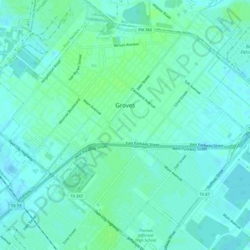
Naam: Topografische kaart Groves, hoogte, reliëf.
Locatie: Groves, Jefferson County, Texas, 77619, United States (29.92488 -93.94477 29.96423 -93.89173)
Gemiddelde hoogte: 4 m
Minimale hoogte: -2 m
Maximale hoogte: 9 m
Andere topografische kaarten
Klik op een kaart om zijn topografie, zijn hoogte en zijn reliëf te bekijken.