
Topografische kaart Izumo
Interactieve kaart
Klik op de kaart om de hoogte weer te geven.
Over deze kaart
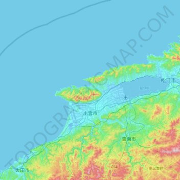
Naam: Topografische kaart Izumo, hoogte, reliëf.
Locatie: Izumo, Shimane Prefecture, Japan (35.16003 132.36459 35.71148 132.93441)
Gemiddelde hoogte: 83 m
Minimale hoogte: -4 m
Maximale hoogte: 760 m
Izumo is located in central eastern of Shimane Prefecture. It has the second largest population in Shimane Prefecture after Matsue, and the third largest population in the San'in region after Matsue and Tottori. Centered on the Izumo Plain, the northern part of the city borders the Shimane Peninsula and the Sea of Japan, and the southern part borders the Chugoku Mountains. The Hii River flows through the eastern part of the city, and it empties into Lake Shinji. The city has a variety of topography, including the sea, mountains, rivers, lakes, plains, canyons, and hot springs.
Andere topografische kaarten
Klik op een kaart om zijn topografie, zijn hoogte en zijn reliëf te bekijken.
Biratori
Biratori, Saru County, Hidaka Subprefecture, Hokkaido Prefecture, Japan
Gemiddelde hoogte: 185 m
Toshima Island
Toshima Island, Maizuru, Kyoto Prefecture, Japan
Gemiddelde hoogte: 21 m
Niseko
Niseko, Abuta County, Shiribeshi Subprefecture, Hokkaido Prefecture, Japan
Gemiddelde hoogte: 339 m
Noto
Noto, Houshi County, Ishikawa Prefecture, Chubu Region, Japan
Gemiddelde hoogte: 56 m
Kitanakagusuku
Kitanakagusuku, Nakagami, Okinawa Prefecture, Japan
Gemiddelde hoogte: 59 m
Watarase Usuichi
Watarase Usuichi, Tochigi, Tochigi Prefecture, 374-0112, Japan
Gemiddelde hoogte: 18 m
Saza
Saza, Kita-Matsuura County, Nagasaki Prefecture, 857-0322, Japan
Gemiddelde hoogte: 111 m
Arita
Arita, Nishi-Matsuura County, Saga Prefecture, Japan
Gemiddelde hoogte: 184 m
Sagara
Sagara, Kuma County, Kumamoto Prefecture, 868-0094, Japan
Gemiddelde hoogte: 422 m
Nakaniikawa County
Nakaniikawa County, Toyama Prefecture, Chubu Region, Japan
Gemiddelde hoogte: 665 m
Furuu County
Furuu County, Shiribeshi Subprefecture, Hokkaido Prefecture, Japan
Gemiddelde hoogte: 124 m
Manazuru
Manazuru, Ashigarashimo County, Kanagawa Prefecture, 259-0201, Japan
Gemiddelde hoogte: 206 m