
Topografische kaart Mount Saint Elias
Interactieve kaart
Klik op de kaart om de hoogte weer te geven.
Over deze kaart
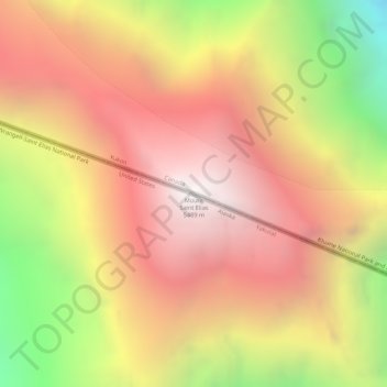
Naam: Topografische kaart Mount Saint Elias, hoogte, reliëf.
Locatie: Mount Saint Elias, Yakutat, Alaska, VS (60.29340 -140.93079 60.29350 -140.93069)
Gemiddelde hoogte: 4.672 m
Minimale hoogte: 3.530 m
Maximale hoogte: 5.467 m
Andere topografische kaarten
Klik op een kaart om zijn topografie, zijn hoogte en zijn reliëf te bekijken.
Glacier Bay National Park
Glacier Bay National Park, Hoonah-Angoon, Alaska, VS
Gemiddelde hoogte: 556 m
Kobuk Valley National Park
Kobuk Valley National Park, Northwest Arctic, Alaska, VS
Gemiddelde hoogte: 331 m
Gates of the Arctic
Gates of the Arctic, Unorganized Borough, Alaska, VS
Gemiddelde hoogte: 663 m
Kenai Fjords National Park
Kenai Fjords National Park, Kenai Peninsula, Alaska, VS
Gemiddelde hoogte: 518 m