
Topografische kaart San Pascual
Interactieve kaart
Klik op de kaart om de hoogte weer te geven.
Over deze kaart
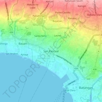
Naam: Topografische kaart San Pascual, hoogte, reliëf.
Locatie: San Pascual, Batangas, Calabarzon, 4204, Philippines (13.74449 120.99022 13.82449 121.07022)
Gemiddelde hoogte: 41 m
Minimale hoogte: -1 m
Maximale hoogte: 142 m
Andere topografische kaarten
Klik op een kaart om zijn topografie, zijn hoogte en zijn reliëf te bekijken.
Natunuan South
Philippines > Batangas > San Pascual
Natunuan South, San Pascual, Batangas, Calabarzon, 4204, Philippines
Gemiddelde hoogte: 132 m
Santo Niño
Philippines > Batangas > San Pascual
Santo Niño, San Pascual, Batangas, Calabarzon, 4204, Philippines
Gemiddelde hoogte: 46 m
Pook ni Banal
Philippines > Batangas > San Pascual > Pook ni Banal
Pook ni Banal, San Pascual, Batangas, Calabarzon, 4204, Philippines
Gemiddelde hoogte: 131 m