
Topografische kaart Mount Terror
Interactieve kaart
Klik op de kaart om de hoogte weer te geven.
Over deze kaart
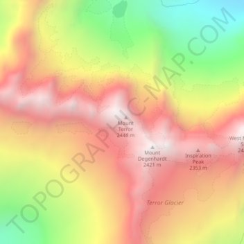
Naam: Topografische kaart Mount Terror, hoogte, reliëf.
Locatie: Mount Terror, Whatcom County, Washington, VS (48.77424 -121.29962 48.77434 -121.29952)
Gemiddelde hoogte: 1.808 m
Minimale hoogte: 967 m
Maximale hoogte: 2.436 m
Andere topografische kaarten
Klik op een kaart om zijn topografie, zijn hoogte en zijn reliëf te bekijken.
Maple Valley
VS > Washington > Maple Valley
Maple Valley, King County, Washington, 98038, VS
Gemiddelde hoogte: 160 m
North Cascades National Park
VS > Washington
North Cascades National Park, Whatcom County, Washington, VS
Gemiddelde hoogte: 1.151 m
Bellingham
VS > Washington > Bellingham
Bellingham, Whatcom County, Washington, VS
Gemiddelde hoogte: 89 m