
Topografische kaart Traverse City
Interactieve kaart
Klik op de kaart om de hoogte weer te geven.
Over deze kaart
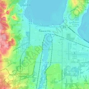
Naam: Topografische kaart Traverse City, hoogte, reliëf.
Gemiddelde hoogte: 204 m
Minimale hoogte: 174 m
Maximale hoogte: 307 m
The locale and topography is conducive for road bicycling, aided by the TART trail system. A map with routes, different trips, advice and local knowledge is available. Lake Michigan presents a location for sailing, fishing, and kayaking.
Andere topografische kaarten
Klik op een kaart om zijn topografie, zijn hoogte en zijn reliëf te bekijken.
Grand Traverse Bay
United States > Michigan > Grand Traverse County
Grand Traverse Bay, Grand Traverse County, Michigan, 49682, United States
Gemiddelde hoogte: 201 m
Interlochen
United States > Michigan > Grand Traverse County
Interlochen, Green Lake Township, Grand Traverse County, Michigan, 49643, United States
Gemiddelde hoogte: 257 m
Williamsburg
United States > Michigan > Grand Traverse County
Williamsburg, Whitewater Township, Grand Traverse County, Michigan, 49690, United States
Gemiddelde hoogte: 228 m
East Bay Township
United States > Michigan > Grand Traverse County
East Bay Township, Grand Traverse County, Michigan, United States
Gemiddelde hoogte: 252 m