
Topografische kaart Manuel Cornejo Astorga (Tandapi)
Interactieve kaart
Klik op de kaart om de hoogte weer te geven.
Over deze kaart
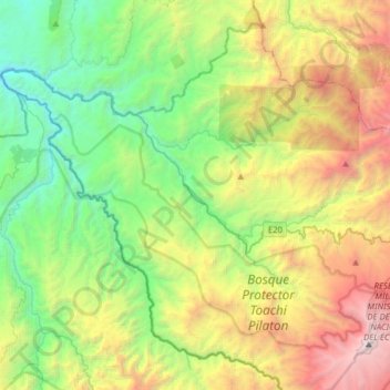
Naam: Topografische kaart Manuel Cornejo Astorga (Tandapi), hoogte, reliëf.
Locatie: Manuel Cornejo Astorga (Tandapi), Mejía, Pichincha, Ecuador (-0.55022 -78.95442 -0.27596 -78.64314)
Gemiddelde hoogte: 2.201 m
Minimale hoogte: 848 m
Maximale hoogte: 4.769 m