
Topografische kaart Mauna Kea
Interactieve kaart
Klik op de kaart om de hoogte weer te geven.
Over deze kaart
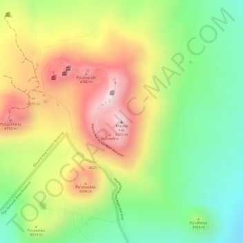
Naam: Topografische kaart Mauna Kea, hoogte, reliëf.
Gemiddelde hoogte: 3.979 m
Minimale hoogte: 3.759 m
Maximale hoogte: 4.209 m
Andere topografische kaarten
Klik op een kaart om zijn topografie, zijn hoogte en zijn reliëf te bekijken.
Hawai'i Volcanoes National Park
United States of America (Island of Hawai'i territorial waters) > Hawaï > Hilo
Hawai'i Volcanoes National Park, Keauhou Trail, Hilo, Hawaiʻi County, Hawaï, United States of America (Island of Hawai'i territorial waters)
Gemiddelde hoogte: 688 m