
Topografische kaart Sint-Pietersberg
Interactieve kaart
Klik op de kaart om de hoogte weer te geven.
Over deze kaart
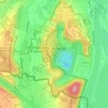
Naam: Topografische kaart Sint-Pietersberg, hoogte, reliëf.
Gemiddelde hoogte: 71 m
Minimale hoogte: 10 m
Maximale hoogte: 153 m
Andere topografische kaarten
Klik op een kaart om zijn topografie, zijn hoogte en zijn reliëf te bekijken.
Maas
Nederland > Limburg > Maastricht > Borgharen
Er is dan ook vaak hoogwater op de Maas. Het hoogste waterpeil van de afgelopen eeuwen bereikte de rivier tijdens de overstroming van januari 1643, waarbij grote verwoestingen werden aangericht en honderden doden te betreuren waren. Door de verbreding en verdieping van de Maas (vanaf 1840) werd het water…
Gemiddelde hoogte: 49 m
Lage Fronten
Nederland > Limburg > Maastricht
De kazemat aan de zuidwestzijde van ravelijn a diende na de opheffing van de vesting onder andere als woning voor de opzichter van de gemeentelijke vuilnisbelt en als gemeentelijke wintertuin voor planten. Later werden de gemeentelijk ophaalkarren van fecaliën hier geleegd. De kazemat kon in 1953 bij de…
Gemiddelde hoogte: 57 m