
Topografische kaart Entre Ríos
Interactieve kaart
Klik op de kaart om de hoogte weer te geven.
Over deze kaart
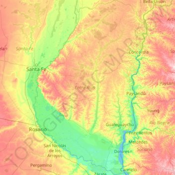
Naam: Topografische kaart Entre Ríos, hoogte, reliëf.
Locatie: Entre Ríos, Argentinië (-34.03919 -60.77165 -30.15896 -57.79739)
Gemiddelde hoogte: 53 m
Minimale hoogte: -1 m
Maximale hoogte: 206 m
Andere topografische kaarten
Klik op een kaart om zijn topografie, zijn hoogte en zijn reliëf te bekijken.
Gualeguay
Argentinië > Entre Ríos > Distrito Cuchilla > Gualeguay
Gualeguay, Distrito Cuchilla, Departamento Gualeguay, Entre Ríos, Argentinië
Gemiddelde hoogte: 9 m
Villa Elisa
Argentinië > Entre Ríos > Distrito Segundo > Villa Elisa
Villa Elisa, Municipio Villa Elisa, Distrito Segundo, Departamento Colón, Entre Ríos, E3265, Argentinië
Gemiddelde hoogte: 48 m
El Cerro
Argentinië > Entre Ríos > Distrito Mandisoví > Chajarí
El Cerro, Chajarí, Distrito Mandisoví, Departamento Federación, Entre Ríos, Argentinië
Gemiddelde hoogte: 55 m