
Topografische kaart Florenville
Interactieve kaart
Klik op de kaart om de hoogte weer te geven.
Over deze kaart
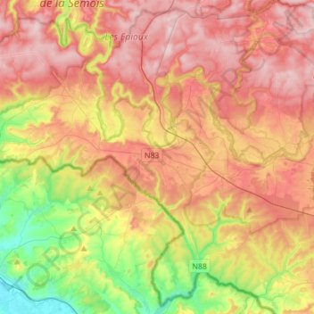
Naam: Topografische kaart Florenville, hoogte, reliëf.
Locatie: Florenville, Virton, Luxemburg, Wallonië, België (49.61078 5.14709 49.78127 5.42495)
Gemiddelde hoogte: 316 m
Minimale hoogte: 160 m
Maximale hoogte: 452 m
Andere topografische kaarten
Klik op een kaart om zijn topografie, zijn hoogte en zijn reliëf te bekijken.
Semois
België > Luxemburg > Virton > Les Bulles
Semois, Les Bulles, Chiny, Virton, Luxemburg, Wallonië, 6811, België
Gemiddelde hoogte: 332 m
Sainte-Cécile
België > Luxemburg > Virton > Sainte-Cécile
Sainte-Cécile, Florenville, Virton, Luxemburg, Wallonië, België
Gemiddelde hoogte: 348 m
Saint-Mard
België > Luxemburg > Virton > Virton
Saint-Mard, Virton, Luxemburg, Wallonië, 6762, België
Gemiddelde hoogte: 272 m
Gérouville
België > Luxemburg > Virton > Gérouville
Gérouville, Meix-devant-Virton, Virton, Luxemburg, Wallonië, 6769, België
Gemiddelde hoogte: 291 m