
Topografische kaart Galveston County
Interactieve kaart
Klik op de kaart om de hoogte weer te geven.
Over deze kaart
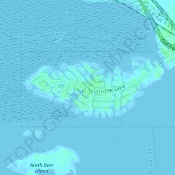
Naam: Topografische kaart Galveston County, hoogte, reliëf.
Locatie: Galveston County, Texas, VS (29.29259 -94.92950 29.30254 -94.90392)
Gemiddelde hoogte: 0 m
Minimale hoogte: -1 m
Maximale hoogte: 5 m
Andere topografische kaarten
Klik op een kaart om zijn topografie, zijn hoogte en zijn reliëf te bekijken.
Point Loma
VS > Texas > Point Loma
Point Loma, San Patricio County, Texas, 78368, VS
Gemiddelde hoogte: 34 m
Jesus Maria Colonia
VS > Texas > Jesus Maria Colonia
Jesus Maria Colonia, Hidalgo County, Texas, 78579, VS
Gemiddelde hoogte: 23 m
North Shore
VS > Texas > North Shore
North Shore, Harris County, Texas, 77339, VS
Gemiddelde hoogte: 21 m