
Topografische kaart Hokkaido
Interactieve kaart
Klik op de kaart om de hoogte weer te geven.
Over deze kaart
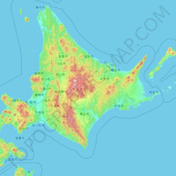
Naam: Topografische kaart Hokkaido, hoogte, reliëf.
Locatie: Hokkaido, Japan (41.39767 139.76604 45.52294 145.81746)
Gemiddelde hoogte: 98 m
Minimale hoogte: -2 m
Maximale hoogte: 2.270 m
As Japan's coldest region, Hokkaidō has relatively cool summers and icy/snowy winters. Most of the island falls in the humid continental climate zone with Köppen climate classification Dfb (hemiboreal) in most areas but Dfa (hot summer humid continental) in some inland lowlands. The average August temperature ranges from 17 to 22 °C (62.6 to 71.6 °F), while the average January temperature ranges from −12 to −4 °C (10.4 to 24.8 °F), in both cases depending on elevation and distance from the ocean, though temperatures on the western side of the island tend to be a little warmer than on the eastern. The highest temperature ever recorded is 39.5 °C (103.1 °F) on 26 May 2019.
Andere topografische kaarten
Klik op een kaart om zijn topografie, zijn hoogte en zijn reliëf te bekijken.
Ozora
Ozora, Abashiri County, Okhotsk Subprefecture, Hokkaido Prefecture, Japan
Gemiddelde hoogte: 113 m
Biratori
Biratori, Saru County, Hidaka Subprefecture, Hokkaido Prefecture, Japan
Gemiddelde hoogte: 185 m
Toshima Island
Toshima Island, Maizuru, Kyoto Prefecture, Japan
Gemiddelde hoogte: 21 m
Niseko
Niseko, Abuta County, Shiribeshi Subprefecture, Hokkaido Prefecture, Japan
Gemiddelde hoogte: 339 m
Noto
Noto, Houshi County, Ishikawa Prefecture, Chubu Region, Japan
Gemiddelde hoogte: 56 m
Kitanakagusuku
Kitanakagusuku, Nakagami, Okinawa Prefecture, Japan
Gemiddelde hoogte: 59 m
Watarase Usuichi
Watarase Usuichi, Tochigi, Tochigi Prefecture, 374-0112, Japan
Gemiddelde hoogte: 18 m
Saza
Saza, Kita-Matsuura County, Nagasaki Prefecture, 857-0322, Japan
Gemiddelde hoogte: 111 m
Arita
Arita, Nishi-Matsuura County, Saga Prefecture, Japan
Gemiddelde hoogte: 184 m
Sagara
Sagara, Kuma County, Kumamoto Prefecture, 868-0094, Japan
Gemiddelde hoogte: 422 m
Nakaniikawa County
Nakaniikawa County, Toyama Prefecture, Chubu Region, Japan
Gemiddelde hoogte: 665 m
Hakone
Hakone, Ashigarashimo County, Kanagawa Prefecture, Japan
Gemiddelde hoogte: 722 m
Furuu County
Furuu County, Shiribeshi Subprefecture, Hokkaido Prefecture, Japan
Gemiddelde hoogte: 124 m
Manazuru
Manazuru, Ashigarashimo County, Kanagawa Prefecture, 259-0201, Japan
Gemiddelde hoogte: 206 m