
Topografische kaart Gradac
Interactieve kaart
Klik op de kaart om de hoogte weer te geven.
Over deze kaart
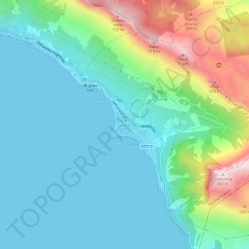
Naam: Topografische kaart Gradac, hoogte, reliëf.
Locatie: Gradac, Općina Gradac, 21330, Croatia (43.08645 17.32169 43.12645 17.36169)
Gemiddelde hoogte: 182 m
Minimale hoogte: 0 m
Maximale hoogte: 747 m
Under its present name, Gradac was mentioned for the first time in 1649. It was named after the stronghold that was situated on the elevation above the present-day church of St. Michael, and which was built probably during the Cretan War (1645–1669) as a defence against the Turks. According to the drawing made by the Venetian military engineer and cartographer Giuseppe Santini, representing the naval and continental battles between the Venetians and Ottomans at Gradac in the year 1666, the tower is shown in flames.