
Topografische kaart Ballymoney
Interactieve kaart
Klik op de kaart om de hoogte weer te geven.
Over deze kaart
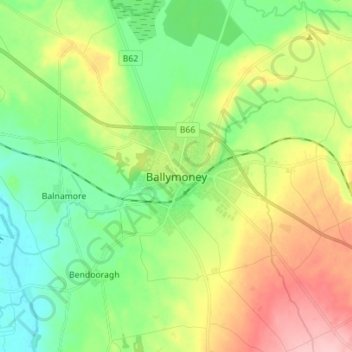
Naam: Topografische kaart Ballymoney, hoogte, reliëf.
Gemiddelde hoogte: 51 m
Minimale hoogte: 0 m
Maximale hoogte: 137 m
In 1837, Lewis's Topographical Dictionary of Ireland, describes Ballymoney as "a market-town and post-town" containing 2,222 inhabitants (11,579 in the broader civil parish) with a long established linen market chiefly supplying the London market, and with "a very extensive trade ... in grain, butter, pork, and general provisions". Transport was largely via the Bann. By 1860, the town was connected to both Belfast and Derry by rail.
Andere topografische kaarten
Klik op een kaart om zijn topografie, zijn hoogte en zijn reliëf te bekijken.
Belfast
United Kingdom > Northern Ireland > County Antrim
Belfast, County Antrim, Northern Ireland, BT1 5GS, United Kingdom
Gemiddelde hoogte: 87 m
Portballintrae
United Kingdom > Northern Ireland > County Antrim
Portballintrae, County Antrim, Northern Ireland, BT57 8RZ, United Kingdom
Gemiddelde hoogte: 27 m
Portglenone
United Kingdom > Northern Ireland > County Antrim
Portglenone, County Antrim, Northern Ireland, BT44 8AD, United Kingdom
Gemiddelde hoogte: 43 m
Martinstown
United Kingdom > Northern Ireland > County Antrim
Martinstown, County Antrim, Northern Ireland, BT43 6QH, United Kingdom
Gemiddelde hoogte: 174 m
Tildarg
United Kingdom > Northern Ireland > County Antrim
Tildarg, County Antrim, Northern Ireland, BT39 9ZW, United Kingdom
Gemiddelde hoogte: 204 m
Nutts Corner
United Kingdom > Northern Ireland > County Antrim
Nutts Corner, County Antrim, Northern Ireland, BT29 4SR, United Kingdom
Gemiddelde hoogte: 105 m
Ballygomartin
United Kingdom > Northern Ireland > County Antrim > Belfast
Ballygomartin, Ligoniel, Belfast, County Antrim, Northern Ireland, United Kingdom
Gemiddelde hoogte: 258 m
Aghagallon
United Kingdom > Northern Ireland > County Antrim
Aghagallon, County Antrim, Northern Ireland, BT67 0AR, United Kingdom
Gemiddelde hoogte: 31 m
Ballymena
United Kingdom > Northern Ireland > County Antrim
Ballymena, County Antrim, Northern Ireland, BT43 6DT, United Kingdom
Gemiddelde hoogte: 74 m
Lisburn
United Kingdom > Northern Ireland > County Antrim
Lisburn, County Antrim, Northern Ireland, BT28 1BJ, United Kingdom
Gemiddelde hoogte: 92 m
Whitehead
United Kingdom > Northern Ireland > County Antrim
Whitehead, County Antrim, Northern Ireland, BT38 9RU, United Kingdom
Gemiddelde hoogte: 37 m
Botanic Gardens
United Kingdom > Northern Ireland > County Antrim > Belfast
Botanic Gardens, Queen's Quarter, Belfast, County Antrim, Northern Ireland, United Kingdom
Gemiddelde hoogte: 15 m
Carrickfergus
United Kingdom > Northern Ireland > County Antrim
Carrickfergus, County Antrim, Northern Ireland, BT38 7AN, United Kingdom
Gemiddelde hoogte: 49 m
Lough Neagh
United Kingdom > Northern Ireland > County Antrim
Lough Neagh, County Antrim, Ulster, Northern Ireland, United Kingdom
Gemiddelde hoogte: 29 m
Upper Ballinderry
United Kingdom > Northern Ireland > County Antrim
Upper Ballinderry, County Antrim, Ulster, Northern Ireland, BT28 2LW, United Kingdom
Gemiddelde hoogte: 74 m
Ballyclare
United Kingdom > Northern Ireland > County Antrim
Ballyclare, County Antrim, Northern Ireland, BT39 9BB, United Kingdom
Gemiddelde hoogte: 120 m
Lisnacrogher
United Kingdom > Northern Ireland > County Antrim
Lisnacrogher, County Antrim, Ulster, Northern Ireland, United Kingdom
Gemiddelde hoogte: 108 m
Old Mill
United Kingdom > Northern Ireland > County Antrim > Ballygally
Old Mill, Ballygally, County Antrim, Ulster, Northern Ireland, BT40 2RX, United Kingdom
Gemiddelde hoogte: 47 m
Straid
United Kingdom > Northern Ireland > County Antrim
Straid, County Antrim, Ulster, Northern Ireland, BT39 9NQ, United Kingdom
Gemiddelde hoogte: 177 m
Ballintoy
United Kingdom > Northern Ireland > County Antrim
Ballintoy, County Antrim, Ulster, Northern Ireland, BT54 6LX, United Kingdom
Gemiddelde hoogte: 73 m
Maghaberry
United Kingdom > Northern Ireland > County Antrim
Maghaberry, County Antrim, Ulster, Northern Ireland, BT67 0JE, United Kingdom
Gemiddelde hoogte: 65 m
Ballycastle
United Kingdom > Northern Ireland > County Antrim
Ballycastle, County Antrim, Northern Ireland, BT54 6AW, United Kingdom
Gemiddelde hoogte: 79 m
Cullybackey
United Kingdom > Northern Ireland > County Antrim
Cullybackey, County Antrim, Ulster, Northern Ireland, BT42 1NH, United Kingdom
Gemiddelde hoogte: 92 m
Larne
United Kingdom > Northern Ireland > County Antrim
Larne, County Antrim, Northern Ireland, BT40 1JS, United Kingdom
Gemiddelde hoogte: 54 m
Armoy
United Kingdom > Northern Ireland > County Antrim
Armoy, County Antrim, Ulster, Northern Ireland, BT53 8RH, United Kingdom
Gemiddelde hoogte: 102 m
Dunadry
United Kingdom > Northern Ireland > County Antrim
Dunadry, County Antrim, Ulster, Northern Ireland, BT41 4QT, United Kingdom
Gemiddelde hoogte: 66 m
Cavehill
United Kingdom > Northern Ireland > County Antrim > Belfast
Cavehill, Belfast, County Antrim, Northern Ireland, BT36 7PN, United Kingdom
Gemiddelde hoogte: 188 m
Portrush
United Kingdom > Northern Ireland > County Antrim
Portrush, County Antrim, Northern Ireland, BT56 8BN, United Kingdom
Gemiddelde hoogte: 23 m
Kinbane Castle
United Kingdom > Northern Ireland > County Antrim > Ballycastle
Kinbane Castle, Whitepark Road, Ballycastle, County Antrim, Northern Ireland, BT54 6GA, United Kingdom
Gemiddelde hoogte: 37 m
Dunloy
United Kingdom > Northern Ireland > County Antrim
Dunloy, County Antrim, Northern Ireland, BT44 9EF, United Kingdom
Gemiddelde hoogte: 128 m
Cargan
United Kingdom > Northern Ireland > County Antrim > Cargan
Cargan, County Antrim, Ulster, Northern Ireland, BT43 6RB, United Kingdom
Gemiddelde hoogte: 246 m
Kells
United Kingdom > Northern Ireland > County Antrim
Kells, County Antrim, Ulster, Northern Ireland, BT42 3LS, United Kingdom
Gemiddelde hoogte: 90 m
McArt's Fort
United Kingdom > Northern Ireland > County Antrim > Belfast
McArt's Fort, Ben Madigan Heights, Whitewell, Belfast, County Antrim, Northern Ireland, BT36 7RW, United Kingdom
Gemiddelde hoogte: 165 m
Randalstown
United Kingdom > Northern Ireland > County Antrim
Randalstown, County Antrim, Northern Ireland, BT41 3AD, United Kingdom
Gemiddelde hoogte: 57 m
Glengormley
United Kingdom > Northern Ireland > County Antrim > Newtownabbey
Glengormley, Newtownabbey, County Antrim, Northern Ireland, United Kingdom
Gemiddelde hoogte: 154 m
Magheragall
United Kingdom > Northern Ireland > County Antrim > Lisburn
Magheragall, Lisburn, County Antrim, Northern Ireland, BT28 2XF, United Kingdom
Gemiddelde hoogte: 52 m
Islandmagee
United Kingdom > Northern Ireland > County Antrim
Islandmagee, County Antrim, Northern Ireland, BT40 3SH, United Kingdom
Gemiddelde hoogte: 23 m
Antrim
United Kingdom > Northern Ireland > County Antrim
Antrim, County Antrim, Northern Ireland, BT41 4AR, United Kingdom
Gemiddelde hoogte: 50 m
Kilwaughter
United Kingdom > Northern Ireland > County Antrim > Kilwaughter
Kilwaughter, County Antrim, Northern Ireland, BT40 2PT, United Kingdom
Gemiddelde hoogte: 161 m
Dunmurry
United Kingdom > Northern Ireland > County Antrim > Lisburn
Dunmurry, Lisburn, County Antrim, Ulster, Northern Ireland, United Kingdom
Gemiddelde hoogte: 38 m
Rasharkin
United Kingdom > Northern Ireland > County Antrim
Rasharkin, County Antrim, Northern Ireland, BT44 8RX, United Kingdom
Gemiddelde hoogte: 89 m
Dervock
United Kingdom > Northern Ireland > County Antrim > Dervock
Dervock, County Antrim, Northern Ireland, BT53 8BT, United Kingdom
Gemiddelde hoogte: 44 m
Tamybuck
United Kingdom > Northern Ireland > County Antrim > Aughafatten
Tamybuck, Aughafatten, County Antrim, Northern Ireland, BT42 4LP, United Kingdom
Gemiddelde hoogte: 171 m
Cushendun
United Kingdom > Northern Ireland > County Antrim
Cushendun, County Antrim, Ulster, Northern Ireland, BT44 0PH, United Kingdom
Gemiddelde hoogte: 59 m
Edenderry
United Kingdom > Northern Ireland > County Antrim > Belfast
Edenderry, Woodvale, Belfast, County Antrim, Northern Ireland, United Kingdom
Gemiddelde hoogte: 50 m
Bushmills
United Kingdom > Northern Ireland > County Antrim
Bushmills, County Antrim, Northern Ireland, BT57 8QB, United Kingdom
Gemiddelde hoogte: 42 m
Carnlough
United Kingdom > Northern Ireland > County Antrim
Carnlough, County Antrim, Ulster, Northern Ireland, BT44 0EU, United Kingdom
Gemiddelde hoogte: 77 m
Ahoghill
United Kingdom > Northern Ireland > County Antrim
Ahoghill, County Antrim, Northern Ireland, BT42 1JZ, United Kingdom
Gemiddelde hoogte: 84 m
Newtownabbey
United Kingdom > Northern Ireland > County Antrim
Newtownabbey, County Antrim, Northern Ireland, BT36 6UN, United Kingdom
Gemiddelde hoogte: 100 m
Glenavy
United Kingdom > Northern Ireland > County Antrim
Glenavy, County Antrim, Northern Ireland, BT29 4PP, United Kingdom
Gemiddelde hoogte: 76 m