
Topografische kaart Barton Stacey
Interactieve kaart
Klik op de kaart om de hoogte weer te geven.
Over deze kaart
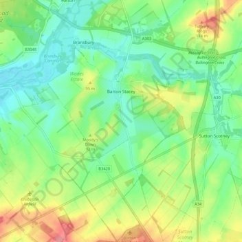
Naam: Topografische kaart Barton Stacey, hoogte, reliëf.
Gemiddelde hoogte: 75 m
Minimale hoogte: 43 m
Maximale hoogte: 139 m
Andere topografische kaarten
Klik op een kaart om zijn topografie, zijn hoogte en zijn reliëf te bekijken.
Kimpton
United Kingdom > England > Test Valley
Kimpton, Test Valley, Hampshire, South East, England, United Kingdom
Gemiddelde hoogte: 111 m
Test Valley
United Kingdom > England > Test Valley
Test Valley, Hampshire, South East, England, United Kingdom
Gemiddelde hoogte: 97 m
Chilworth
United Kingdom > England > Test Valley
Chilworth, Test Valley, Hampshire, South East, England, United Kingdom
Gemiddelde hoogte: 49 m
Romsey
United Kingdom > England > Test Valley
Romsey, Test Valley, Hampshire, South East, England, United Kingdom
Gemiddelde hoogte: 25 m