
Topografische kaart Sequoia National Forest
Interactieve kaart
Klik op de kaart om de hoogte weer te geven.
Over deze kaart
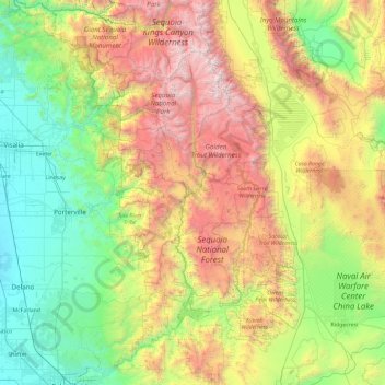
Naam: Topografische kaart Sequoia National Forest, hoogte, reliëf.
Gemiddelde hoogte: 1.331 m
Minimale hoogte: 68 m
Maximale hoogte: 4.288 m
The Sequoia National Forest covers 1,193,315 acres (1,864.555 sq mi; 4,829.17 km2), and ranges in elevation from 1,000 feet (300 m) in the foothills of the Sierra Nevada to over 12,000 feet (3,700 m). Its giant sequoia (Sequoiadendron giganteum) groves are part of its 196,000 acres (790 km2) of old growth forests. Other tree species include: