
Topografische kaart Bydgoszcz
Interactieve kaart
Klik op de kaart om de hoogte weer te geven.
Over deze kaart
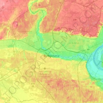
Naam: Topografische kaart Bydgoszcz, hoogte, reliëf.
Locatie: Bydgoszcz, Kuyavian-Pomeranian Voivodeship, Poland (53.05011 17.87417 53.20934 18.20171)
Gemiddelde hoogte: 71 m
Minimale hoogte: 26 m
Maximale hoogte: 113 m
The etymology of the German name of the town developed later and derives from the river Brahe (Brda in Polish), on whose banks the city is located, and berg, elevation, mount(ain), combined to 'Brahenberg', with 'a' pronounced in East Pomeranian Low German rather like 'å', later contracted to Bromberg, dropping the weak 'h', with the 'n' assimilated as 'm' to the following labial sound 'b'.
Andere topografische kaarten
Klik op een kaart om zijn topografie, zijn hoogte en zijn reliëf te bekijken.
Tatrzańskie
Poland > Kuyavian-Pomeranian Voivodeship > Bydgoszcz
Tatrzańskie, Bydgoszcz, Kuyavian-Pomeranian Voivodeship, Poland
Gemiddelde hoogte: 71 m