
Topografische kaart Bradenton
Interactieve kaart
Klik op de kaart om de hoogte weer te geven.
Over deze kaart
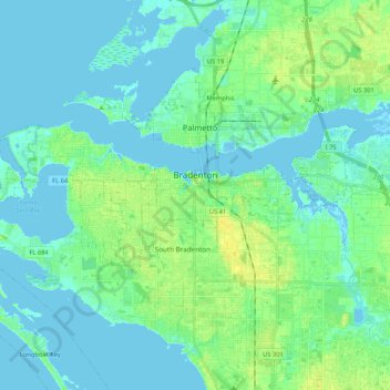
Naam: Topografische kaart Bradenton, hoogte, reliëf.
Locatie: Bradenton, Manatee County, Florida, United States (27.45516 -82.69069 27.52296 -82.47943)
Gemiddelde hoogte: 5 m
Minimale hoogte: -5 m
Maximale hoogte: 17 m
Bradenton would be affected by World War II like many other cities in Florida and the United States. During the war, Manatee County would have its own Civil Defense battalion in it with two subunits existing in Bradenton and another for nearby Manatee. A recreational center would be opened in March 1942 at a building on the intersection of 6th Avenue and 12th Street West in the downtown area to be used by soldiers. The recreation center would close in November 1945 and would be popular with local soldiers and visited even by those who were stationed outside of Bradenton. The Bradenton Police Chief, Clyde Benton would expand the police force by naming 45 officers to serve without pay during the war. Camp Weatherford located at LECOM Field would exist for 8 months at some point during the war as a training center for the US Army Signal Corps. About 350 soldiers would be trained there during its existence. The camp itself often had an issue with being flooded because of the rainy climate, showers at the camp occurring often, clothes being washed, its low elevation and is located nearby to Wares Creek. A soldier named Joe Grossman at the camp would run a radio show broadcasting on WSPB called Weatherford Shinings. Local residents would accommodate the troops stationed at the base in a variety of ways. Bradenton would merge with nearby Manatee (incorporated in 1888) in 1943. Manatee would face similar financial problems as Bradenton did in regards to their bonds and faced high debt levels as a result but Manatee could not pay off the bonds.
Andere topografische kaarten
Klik op een kaart om zijn topografie, zijn hoogte en zijn reliëf te bekijken.
De Soto National Memorial
United States > Florida > Manatee County
De Soto National Memorial, Manatee County, Florida, United States
Gemiddelde hoogte: 3 m
South Bradenton
United States > Florida > Manatee County > South Bradenton
South Bradenton, Cedar Hammock, South Bradenton, Manatee County, Florida, United States
Gemiddelde hoogte: 10 m
Ellenton
United States > Florida > Manatee County
Ellenton, Manatee County, Florida, United States
Gemiddelde hoogte: 3 m
Palmetto
United States > Florida > Manatee County
Palmetto, Manatee County, Florida, United States
Gemiddelde hoogte: 4 m
Myakka City
United States > Florida > Manatee County
Myakka City, Manatee County, Florida, United States
Gemiddelde hoogte: 14 m
Ilexhurst
United States > Florida > Manatee County > Holmes Beach
Ilexhurst, Holmes Beach, Manatee County, Florida, 34217, United States
Gemiddelde hoogte: 1 m
Longboat Key
United States > Florida > Manatee County > Longboat Key
Longboat Key, Manatee County, Florida, 34228, United States
Gemiddelde hoogte: 1 m
Anna Maria island
United States > Florida > Manatee County
Anna Maria island, Manatee County, Florida, 34216, United States
Gemiddelde hoogte: 2 m
Ellenton
United States > Florida > Manatee County > Ellenton
Ellenton, Manatee County, Florida, United States
Gemiddelde hoogte: 5 m
Parrish
United States > Florida > Manatee County
Parrish, Manatee County, Florida, 34219, United States
Gemiddelde hoogte: 12 m