
Topografische kaart Panton Hill
Interactieve kaart
Klik op de kaart om de hoogte weer te geven.
Over deze kaart
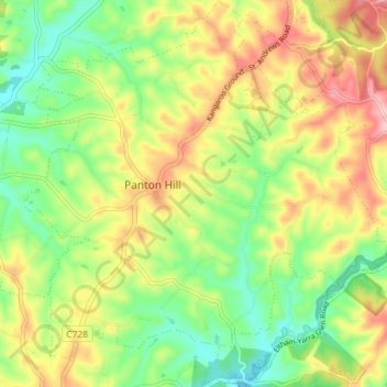
Naam: Topografische kaart Panton Hill, hoogte, reliëf.
Locatie: Panton Hill, Shire of Nillumbik, Victoria, 3759, Australia (-37.67124 145.21507 -37.61422 145.28610)
Gemiddelde hoogte: 152 m
Minimale hoogte: 77 m
Maximale hoogte: 249 m
Andere topografische kaarten
Klik op een kaart om zijn topografie, zijn hoogte en zijn reliëf te bekijken.
Panton Hill
Australia > Victoria > Panton Hill
Panton Hill, Shire of Nillumbik, Victoria, 3759, Australia
Gemiddelde hoogte: 150 m
Cottles Bridge
Australia > Victoria > Panton Hill
Cottles Bridge, Panton Hill, Shire of Nillumbik, Victoria, Australia
Gemiddelde hoogte: 143 m