
Topografische kaart Seymour
Interactieve kaart
Klik op de kaart om de hoogte weer te geven.
Over deze kaart
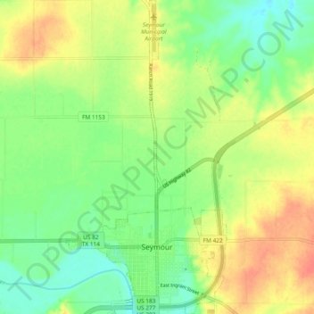
Naam: Topografische kaart Seymour, hoogte, reliëf.
Locatie: Seymour, Baylor County, Texas, 76380, United States (33.57758 -99.28730 33.65528 -99.23953)
Gemiddelde hoogte: 401 m
Minimale hoogte: 379 m
Maximale hoogte: 426 m
The climate is humid subtropical (Köppen: Cfa) with an extreme temperature deviation, but much of the time, the variation is always more and the warm weather prevails over the cold as the averages and the records show. Its subtropical location and south of the center of a large land mass bring occasional outbreaks even to a latitude and not very high altitude. The climate in this area is characterized by hot, humid summers and generally mild to cool winters, sometimes cold. On August 12, 1936, Seymour witnessed the record highest temperature in Texas (120 °F) (49 °C), a record that was tied by the city of Monahans on June 28, 1994.
Andere topografische kaarten
Klik op een kaart om zijn topografie, zijn hoogte en zijn reliëf te bekijken.
Lake Kemp
United States > Texas > Baylor County
Lake Kemp, Baylor County, Texas, United States
Gemiddelde hoogte: 360 m
Red Springs
United States > Texas > Baylor County
Red Springs, Baylor County, Texas, United States
Gemiddelde hoogte: 418 m
Bomarton
United States > Texas > Baylor County
Bomarton, Baylor County, Texas, United States
Gemiddelde hoogte: 429 m
Westover
United States > Texas > Baylor County
Westover, Baylor County, Texas, United States
Gemiddelde hoogte: 393 m
Mabelle
United States > Texas > Baylor County
Mabelle, Baylor County, Texas, United States
Gemiddelde hoogte: 395 m
Seymour
United States > Texas > Baylor County
Seymour, Baylor County, Texas, 76380, United States
Gemiddelde hoogte: 401 m