
Topografische kaart Cochrane
Interactieve kaart
Klik op de kaart om de hoogte weer te geven.
Over deze kaart
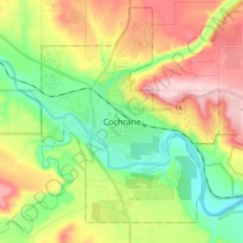
Naam: Topografische kaart Cochrane, hoogte, reliëf.
Locatie: Cochrane, Town of Cochrane, Alberta, T4V 2A7, Canada (51.14746 -114.51107 51.22746 -114.43107)
Gemiddelde hoogte: 1.205 m
Minimale hoogte: 1.100 m
Maximale hoogte: 1.352 m
Cochrane is situated at the base of Big Hill in the Bow River Valley. It sits at an elevation of 1,186 m (3,891 ft). The town is intersected by Highway 1A and Highway 22. Cochrane has a reputation for its western culture, which can easily be felt when one wanders the streets (particularly Main Street). The town is a popular destination for ice cream and coffee in its quaint western-oriented stores as well as for windsports, golfing, hiking and other adventure activities.