
Topografische kaart Kozhikode
Interactieve kaart
Klik op de kaart om de hoogte weer te geven.
Over deze kaart
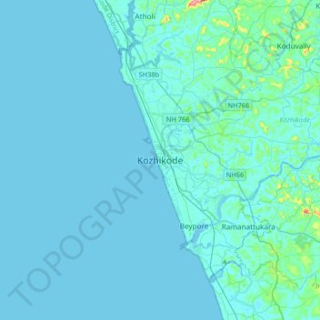
Naam: Topografische kaart Kozhikode, hoogte, reliëf.
Locatie: Kozhikode, Kozhikode District, Kerala, 673001, India (11.08506 75.61547 11.40506 75.93547)
Gemiddelde hoogte: 14 m
Minimale hoogte: -2 m
Maximale hoogte: 272 m
Andere topografische kaarten
Klik op een kaart om zijn topografie, zijn hoogte en zijn reliëf te bekijken.
Sarovaram Bio Park
India > Kerala > Kozhikode > Erenjippalam
Sarovaram Bio Park, Mini Bypass Road, Jawahar Nagar, Erenjippalam, Kozhikode, Kozhikode District, Kerala, 673004, India
Gemiddelde hoogte: 14 m
Chaliyar River
India > Kerala > Kozhikode > Kolathara Chungam
Chaliyar River, Kolathara Chungam, Kozhikode, Kozhikode District, Kerala, India
Gemiddelde hoogte: 29 m
Puranadathil colony
India > Kerala > Kozhikode > Cherukulam
Puranadathil colony, Cherukulam, Kozhikode, Kozhikode District, Kerala, 673317, India
Gemiddelde hoogte: 14 m
Eranhipalam
India > Kerala > Kozhikode > Erenjippalam
Eranhipalam, Jawahar Nagar, Erenjippalam, Kozhikode, Kozhikode district, Kerala, 673006, India
Gemiddelde hoogte: 14 m
Bhagavathiparamb colony
India > Kerala > Kozhikode > Cherukulam
Bhagavathiparamb colony, Cherukulam, Kozhikode, Kozhikode district, Kerala, 673611, India
Gemiddelde hoogte: 14 m
Mananchira
India > Kerala > Kozhikode > Kozhikode
Mananchira, Palayam, Kozhikode, Kozhikode district, Kerala, India
Gemiddelde hoogte: 12 m
Chalappuram
India > Kerala > Kozhikode > Kozhikode
Chalappuram, Pathaya Pura, Kozhikode, Kozhikode district, Kerala, India
Gemiddelde hoogte: 12 m
Mavoor
India > Kerala > Kozhikode > Alin chuvadu
Mavoor, Alin chuvadu, Kozhikode, Kozhikode district, Kerala, India
Gemiddelde hoogte: 20 m
Ramanattukara
Ramanattukara, Kozhikode, Kozhikode district, Kerala, 673633, India
Gemiddelde hoogte: 24 m
Kuttichira
India > Kerala > Kozhikode > Kozhikode
Kuttichira, Pathaya Pura, Kozhikode, Kozhikode district, Kerala, India
Gemiddelde hoogte: 8 m
Kunnamangalam
Kunnamangalam, Kozhikode, Kozhikode District, Kerala, 673571, India
Gemiddelde hoogte: 35 m
Alin chuvadu
India > Kerala > Kozhikode > Alin chuvadu
Alin chuvadu, Kozhikode, Kozhikode district, Kerala, 673661, India
Gemiddelde hoogte: 31 m
Olavanna
India > Kerala > Kozhikode > Pantheerankave
Olavanna, Kozhikode Municipal Corporation - Cheruvannur Nallalam zone, Pantheerankave, Kozhikode, Kozhikode District, Kerala, India
Gemiddelde hoogte: 19 m