
Topografische kaart Madikeri
Interactieve kaart
Klik op de kaart om de hoogte weer te geven.
Over deze kaart
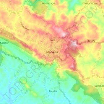
Naam: Topografische kaart Madikeri, hoogte, reliëf.
Locatie: Madikeri, Madikeri taluku, Kodagu, Karnataka, 571201, India (12.38149 75.69875 12.46149 75.77875)
Gemiddelde hoogte: 1.054 m
Minimale hoogte: 880 m
Maximale hoogte: 1.283 m
Madikeri features a tropical highland climate as it has an elevation of 1,170 m (3,840 ft). Madikeri is located at 12°25′N 75°44′E / 12.42°N 75.73°E / 12.42; 75.73. Madikeri lies in the Western Ghats and is a popular hill station. The nearest cities are Hassan to the north, Mangaluru to the west, and Mysuru to the east. Kannur from Kerala is about 100 km (62 mi) away. The nearest international airport is Kannur International Airport which is 80 km (50 mi) away.
Andere topografische kaarten
Klik op een kaart om zijn topografie, zijn hoogte en zijn reliëf te bekijken.
Kalakeri Nidugane
India > Karnataka > Madikeri taluku > Katakeri
Kalakeri Nidugane, Katakeri, Madikeri taluku, Kodagu District, Karnataka, 571201, India
Gemiddelde hoogte: 1.081 m
Makkanduru
India > Karnataka > Madikeri taluku > Makkanduru
Makkanduru, Madikeri taluku, Kodagu, Karnataka, 571201, India
Gemiddelde hoogte: 1.060 m
Murnadu
India > Karnataka > Madikeri taluku > Murnadu
Murnadu, Madikeri taluku, Kodagu, Karnataka, India
Gemiddelde hoogte: 908 m
Katakeri
India > Karnataka > Madikeri taluku > Katakeri
Katakeri, Madikeri taluku, Kodagu, Karnataka, 571201, India
Gemiddelde hoogte: 1.026 m
Yavakapadi
India > Karnataka > Madikeri taluku
Yavakapadi, Madikeri taluku, Kodagu District, Karnataka, 571212, India
Gemiddelde hoogte: 1.116 m