
Topografische kaart Rishikesh
Interactieve kaart
Klik op de kaart om de hoogte weer te geven.
Over deze kaart
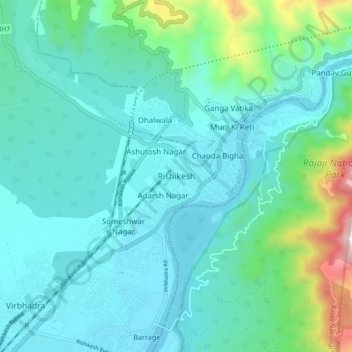
Naam: Topografische kaart Rishikesh, hoogte, reliëf.
Locatie: Rishikesh, Dehradun, Uttarakhand, 249201, India (30.06865 78.25162 30.14865 78.33162)
Gemiddelde hoogte: 497 m
Minimale hoogte: 323 m
Maximale hoogte: 1.363 m
Rishikesh is at 30°06′12″N 78°17′41″E / 30.103368°N 78.294754°E / 30.103368; 78.294754. It has an average elevation of 372 metres (1,220 ft). The town is located in the Tehri Garhwal region of the northern Indian state of Uttarakhand.
Andere topografische kaarten
Klik op een kaart om zijn topografie, zijn hoogte en zijn reliëf te bekijken.
Virbhadra
India > Uttarakhand > Rishikesh
Virbhadra, Rishikesh, Dehradun, Uttarakhand, 249201, India
Gemiddelde hoogte: 356 m