
Topografische kaart Pensacola
Interactieve kaart
Klik op de kaart om de hoogte weer te geven.
Over deze kaart
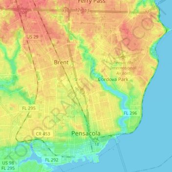
Naam: Topografische kaart Pensacola, hoogte, reliëf.
Locatie: Pensacola, Escambia County, Florida, United States (30.39554 -87.25889 30.51049 -87.14972)
Gemiddelde hoogte: 21 m
Minimale hoogte: -3 m
Maximale hoogte: 46 m
The land is sloped up northward from Pensacola Bay, with most of the city at an elevation above that which a potential hurricane storm surge could affect.
Andere topografische kaarten
Klik op een kaart om zijn topografie, zijn hoogte en zijn reliëf te bekijken.
Navy Point
United States > Florida > Escambia County
Navy Point, Escambia County, Florida, 32512, United States
Gemiddelde hoogte: 8 m
Pensacola Beach
United States > Florida > Escambia County
Pensacola Beach, Escambia County, Florida, 32561, United States
Gemiddelde hoogte: 0 m
Myrtle Grove
United States > Florida > Escambia County > Myrtle Grove
Myrtle Grove, Escambia County, Florida, United States
Gemiddelde hoogte: 13 m
Ensley
United States > Florida > Escambia County > Ensley
Ensley, Escambia County, Florida, United States
Gemiddelde hoogte: 35 m
Cantonment
United States > Florida > Escambia County
Cantonment, Escambia County, Florida, 32533, United States
Gemiddelde hoogte: 38 m