
Topografische kaart Lisburn
Interactieve kaart
Klik op de kaart om de hoogte weer te geven.
Over deze kaart
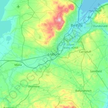
Naam: Topografische kaart Lisburn, hoogte, reliëf.
Gemiddelde hoogte: 92 m
Minimale hoogte: -2 m
Maximale hoogte: 471 m
Andere topografische kaarten
Klik op een kaart om zijn topografie, zijn hoogte en zijn reliëf te bekijken.
Belfast
United Kingdom > Northern Ireland > County Antrim
Belfast, County Antrim, Northern Ireland, United Kingdom
Gemiddelde hoogte: 92 m
Cave Hill
United Kingdom > Northern Ireland > County Antrim > Belfast
Cave Hill, Greencastle, Belfast, County Antrim, Northern Ireland, BT15 5GL, United Kingdom
Gemiddelde hoogte: 172 m
Giant's Causeway
United Kingdom > Northern Ireland > County Antrim
Giant's Causeway, County Antrim, Ulster, Northern Ireland, United Kingdom
Gemiddelde hoogte: 26 m
Ahoghill
United Kingdom > Northern Ireland > County Antrim
Ahoghill, County Antrim, Ulster, Northern Ireland, BT42 1JZ, United Kingdom
Gemiddelde hoogte: 84 m
Upper Ballysillan
United Kingdom > Northern Ireland > County Antrim
Upper Ballysillan, County Antrim, Northern Ireland, United Kingdom
Gemiddelde hoogte: 254 m
Glynn
United Kingdom > Northern Ireland > County Antrim > Glynn
Glynn, County Antrim, Northern Ireland, BT40 3HF, United Kingdom
Gemiddelde hoogte: 63 m
Larne
United Kingdom > Northern Ireland > County Antrim > Larne
Larne, County Antrim, Northern Ireland, BT40 1HU, United Kingdom
Gemiddelde hoogte: 54 m
Belfast
United Kingdom > Northern Ireland > County Antrim
Belfast, County Antrim, Ulster, Northern Ireland, BT1 5GS, United Kingdom
Gemiddelde hoogte: 87 m