
Topografische kaart Reno
Interactieve kaart
Klik op de kaart om de hoogte weer te geven.
Over deze kaart
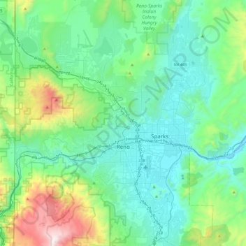
Naam: Topografische kaart Reno, hoogte, reliëf.
Locatie: Reno, Washoe County, Nevada, United States (39.39243 -120.00233 39.72344 -119.69935)
Gemiddelde hoogte: 1.650 m
Minimale hoogte: 1.316 m
Maximale hoogte: 3.010 m
Reno is just east of the Sierra Nevada, on the western edge of the Great Basin at an elevation of about 4,400 feet (1,300 m) above sea level. Numerous faults exist throughout the region. Most of these are normal (vertical motion) faults associated with the uplift of the various mountain ranges, including the Sierra Nevada.
Andere topografische kaarten
Klik op een kaart om zijn topografie, zijn hoogte en zijn reliëf te bekijken.
Cold Springs
United States > Nevada > Washoe County
Cold Springs, Washoe County, Nevada, 89508, United States
Gemiddelde hoogte: 1.573 m
Nixon
United States > Nevada > Washoe County
Nixon, Washoe County, Nevada, 89424, United States
Gemiddelde hoogte: 1.209 m
Incline Village-Crystal Bay
United States > Nevada > Washoe County
Incline Village-Crystal Bay, Washoe County, Nevada, United States
Gemiddelde hoogte: 2.173 m
Sparks
United States > Nevada > Washoe County
Sparks, Washoe County, Nevada, United States
Gemiddelde hoogte: 1.438 m
Oxbow Nature Study Area
United States > Nevada > Washoe County > Reno > West Reno
Oxbow Nature Study Area, West Reno, Reno, Washoe County, Nevada, United States
Gemiddelde hoogte: 1.415 m
North Valley
United States > Nevada > Washoe County > Reno
North Valley, Reno, Washoe County, Nevada, 89512, United States
Gemiddelde hoogte: 1.419 m
Pyramid Lake
United States > Nevada > Washoe County
Pyramid Lake, Washoe County, Nevada, United States
Gemiddelde hoogte: 1.406 m
New Washoe City
United States > Nevada > Washoe County
New Washoe City, Washoe Valley CCD, Washoe County, Nevada, United States
Gemiddelde hoogte: 1.589 m