
Topografische kaart Mussoorie
Interactieve kaart
Klik op de kaart om de hoogte weer te geven.
Mussoorie
Mussoorie is at an average altitude of 2,005 metres (6,578 ft). To the northeast are the Himalayan snow ranges, and to the south, the Doon Valley and Shiwalik ranges. The second highest point is the original Lal Tibba in Landour, with a height of over 2,275 m (7,464 ft). Mussoorie is popularly known as The Queen of the Hills.
Over deze kaart
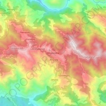
Naam: Topografische kaart Mussoorie, hoogte, reliëf.
Locatie: Mussoorie, Dehradun, Uttarakhand, 248179, India (30.41690 78.03829 30.49690 78.11829)
Gemiddelde hoogte: 1.594 m
Minimale hoogte: 878 m
Maximale hoogte: 2.285 m