
Topografische kaart Almora
Interactieve kaart
Klik op de kaart om de hoogte weer te geven.
Over deze kaart
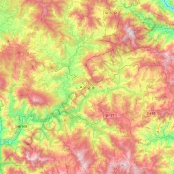
Naam: Topografische kaart Almora, hoogte, reliëf.
Locatie: Almora, Uttarakhand, 263600, India (29.44168 79.50338 29.76168 79.82338)
Gemiddelde hoogte: 1.557 m
Minimale hoogte: 762 m
Maximale hoogte: 2.383 m
Almora is located at 29°35′50″N 79°39′33″E / 29.5971°N 79.6591°E / 29.5971; 79.6591 in Almora district in Uttarakhand. Almora is situated 365 km north-east the national capital New Delhi and 415 km south-east the state capital Dehradun. It lies in the revenue Division Kumaon and is located 63 km north of Nainital, the administrative headquarters of Kumaon. It has an average elevation of 1,861 m (6,106 ft) above mean Sea Level.
Andere topografische kaarten
Klik op een kaart om zijn topografie, zijn hoogte en zijn reliëf te bekijken.
Kosi River
India > Uttarakhand > Almora
Kosi River, Almora, Uttarakhand, 263600, India
Gemiddelde hoogte: 1.436 m
Alaknanda River
India > Uttarakhand > Almora
Alaknanda River, Almora, Uttarakhand, 263600, India
Gemiddelde hoogte: 1.391 m